the Creative Commons Attribution 4.0 License.
the Creative Commons Attribution 4.0 License.
 | 25 Jul 2019
The formation of Middle and Upper Pleistocene terraces (Übergangsterrassen and Hochterrassen) in the Bavarian Alpine Foreland – new numeric dating results (ESR, OSL, 14C) and gastropod fauna analysis
Gerhard Schellmann
Patrick Schielein
Wolfgang Rähle
Christoph Burow
Until now, reliable chronological classifications based on numerical ages for many Pleistocene fluvial deposits in the Alpine Foreland were rare. In this study, new numeric data (ESR, OSL, 14C) from Middle and Upper (Late) Pleistocene Hochterrassen (high terraces) and Übergangsterrassen (transitional terraces) in the Bavarian Alpine Foreland are presented. The dating results imply that the Hochterrassen gravel sensu stricto were deposited during the penultimate glacial (MIS 6, Rissian), and that underlying older gravel accumulation are predominantly of penultimate interglacial (MIS 7, Riss–Riss interglacial) age. In some areas of the Hochterrassen in the Danube valley south of Regensburg (interglacial Hartinger Schichten, Harting layers), and in some areas of the Rainer Hochterrasse (basal gravel unit I), Hochterrassen gravels are underlain by much older interglacial gravel deposits. These interglacial basal gravel deposits illustrate that the downcutting of these valleys far away from areas of Pleistocene foreland glaciations happened predominantly during warm-temperate interglacial or late-glacial periods. One last interglacial (MIS 5e, Riss–Würm interglacial) Hochterrasse is morphologically preserved in the Isar valley. This Jüngere Moosburger Hochterrasse is composed of the Fagotienschotter (Fagotia gravel, named after the gastropod Fagotia acicularis). The next younger terraces are the Early to Middle Würmian (MIS 5d to MIS 3?) Übergangsterrassen (transitional terraces), whereas the younger one of the two Übergangsterrassen was formed most probably during the Middle Würmian (MIS 3).
Chronostratigraphischen Einstufungen pleistozäner fluvialer Ablagerungen und Formen im Alpenvorland mangelt es bis heute an verlässlichen numerischen Altersdaten. Um diese Lücke etwas zu schließen, werden in diesem Beitrag neue numerische Altersdatierungen (ESR, OSL, 14C) von den mittel- und ober (jung)-pleistozänen Hochterrassen und Übergangsterrassen im Bayerischen Alpenvorland vorgestellt. Danach wurden die Hochterrassenschotter sensu stricto im vorletzten Glazial (MIS 6, Riss) und eventuell erhaltene ältere Sockelschotter vor allem im vorletzten Interglazial (MIS 7, inner-RißInterglazial) abgelagert. Das schließt allerdings nicht aus, dass unter einzelnen Hochterrassenschottern wie im Donautal südlich von Regensburg (interglaziale Hartinger Schichten) oder im Bereich der Rainer Hochterrasse (basaler Schotterkörper I) auch noch ältere interglaziale Kieskörper erhalten sein können. Die Relikte warmzeitlicher Sockelschotter weisen darauf hin, dass die Tieferlegung der Talsohlen in Tälern, die weiter von den alpinen Vorlandvergletscherungen entfernt sind, verstärkt in den Inter- und Spätglazialen stattgefunden hat. Letztinterglazialer (Eem, MIS 5e) Herkunft ist die im Isartal erhaltene Jüngere Moosburger Hochterrasse, deren Kieskörper nach den manchmal enthaltenen Schneckenschalen der Gattung Fagotia acicularis auch als Fagotienschotter bezeichnet wird. Die nächst jüngeren Terrassen sind die früh- bis mittelwürmzeitliche (MIS 5d bis MIS 3?) ältere Übergangsterrasse 1 und die mittelwürmzeitliche (MIS 3) jüngere Übergangsterrasse 2.


In the Northern Alpine Foreland, large river valleys like the Danube (German: Donau) valley and its tributaries Iller, Lech and Isar (Fig. 1) are characterised by well-developed stepped fluvial terrace systems, which are partly connected to terminal moraines of Quaternary glaciations in front of the Alps. Penck and Brückner (1901–1909) described these morphostratigraphic relationships between terminal moraines and associated fluvial terraces (respectively fluvial gravel deposits) of different elevations for the first time. They named the four glaciations (from old to young) Günz, Mindel, Riss, and Würm and the associated terrace levels (from old to young) Älterer Deckenschotter (Older Cover Gravel), Jüngerer Deckenschotter (Younger Cover Gravel), Hochterrasse (HT, high terrace, high terrace gravels) and Niederterrasse (NT, lower terrace; lower terrace gravel). In later studies, additional glaciations like the “Donau glaciation” (Eberl, 1930) and “Biber glaciation” (Schaefer, 1957) as well as further fluvial terrace levels like the Hochschotter (highest cover gravel) by Graul (1943) or the Übergangsterrassen (ÜT, transitional terraces; transitional terrace gravel) by Schellmann (1988) have been differentiated.
This article focuses on the Middle to Upper (Late) Pleistocene Hochterrassen and Übergangsterrassen of the Danube, Isar, Lech and Iller rivers. It was Penck (1884) who for the first time used the morphostratigraphic term Hochterrasse for fluvial terraces that are situated some metres (mostly 7 to 15 m) above the valley floors, and the term Niederterrasse for those that are located in the valley floor usually up to 2.5 m above the floodplains. Penck and Brückner (1901–1909) attributed all Hochterrassen to the Rissian (penultimate glaciation, late Middle Pleistocene) and all Niederterrassen to the Würmian glaciation (last glaciation, Upper Pleistocene) of the Alpine Foreland. In more recent studies, further loess-covered terrace levels, the Lower to Middle Würmian Übergangsterrassen (e.g. Schellmann, 1988, 2010; Unger, 1999; Kroemer, 2010; Doppler et al., 2011; Schielein and Schellmann, 2016b), were described between the levels of the Hochterrassen and the Niederterrassen in some valleys (e.g. Danube, Isar, Lech valley). In general, the locally specific morphological position of the Übergangsterrassen and the loess cover is the reason for an occasionally incorrect stratigraphic interpretation of the Übergangsterrassen as Niederterrasse or Hochterrasse, respectively.
Each of these different levels of fluvial terraces within the range of some metres above the modern valley floors can be subdivided additionally into further terrace sublevels with individual fluvial gravel deposits: in some valleys of the Bavarian Alpine Foreland the Hochterrassen can be subdivided morphologically into two (e.g. Penck and Brückner, 1901–1909; Miara, 1996; Miara and Rögner, 1996) or three sublevels (e.g. Schellmann, 1988, 2017b, and further references therein). The terrace gravels are sometimes superimposed on older basal gravel units (e.g. Bibus and Strahl, 2000; Leger, 1988; Schellmann 1988, 1990, 2016b, 2017b; Schellmann et al., 2010; Schielein et al., 2015). Likewise, the Lower to Middle Würmian Übergangsterrassen are sporadically subdivided in two different sublevels (Schellmann, 2010, 2018b; Doppler et al., 2011).
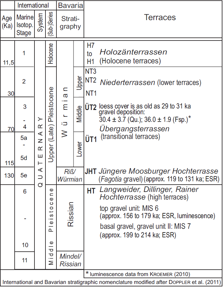
A detailed review of the current stratigraphical system for Quaternary terrace units and for different terminal moraines in southern Bavaria was presented by Doppler et al. (2011). Here, we followed the stratigraphic nomenclature of the Bavarian Geological Survey, which correlates the Würmian to MIS 5d up to MIS 2, the Rissian to MIS 10 up to MIS 6, and the Mindelian to MIS12 and older (cf. Doppler et al., 2011: Table 3).
All in all, Doppler et al. (2011) showed that secure chronological classifications based on numerical ages are rare for many Pleistocene fluvial deposits in the Alpine Foreland. Whereas the age of the Holocene terrace gravels (H) and the Upper Würmian (MIS 2) Niederterrassen gravels in the Bavarian Alpine Foreland is relatively well established by numerous radiocarbon and dendrochronological data from river channel sediments, palaeochannel fills or overlaying floodplain deposits (e.g. Schellmann, 2010, 2016a, 2017a, 2018a; Doppler et al., 2011), numerical ages of the Middle Pleistocene Hochterrassen deposits (e.g. Schielein et al., 2015; Rades et al., 2018, and further references therein) and of the Lower to Middle Würmian Übergangsterrassen deposits are much scarcer (e.g. Doppler et al., 2011; Schellmann, 2010).
The earliest attempts to numerically date the Übergangsterrassen and Hochterrassen in the Bavarian Alpine Foreland started in the late 1980s. Luminescence dating techniques were used focusing on the age determination of the loess cover and the palaeosols on top of the Hochterrassen (Rögner et al., 1988; Zöller, 1995; Miara, 1996; Miara and Rögner, 1996; Becker-Haumann and Frechen, 1997) or the Übergangsterrassen (Buch and Zöller, 1990, see also discussion by Schellmann, 2010; Zöller, 1995). Later, Fiebig and Preusser (2003) presented the first infrared stimulated luminescence (IRSL) measurements on feldspar extracted from sandy layers in Hochterrassen (see Sect. 5) deposits near Ingolstadt, Neuburg and Rain. Thus far, luminescence dating remains the mainly used dating method in the Northern Alpine Foreland. However, luminescence data from fluvial deposits in the Northern Alpine Foreland often suffer from a large scatter in equivalent dose estimates either due to insufficient signal intensities, aberrant luminescence properties, incomplete bleaching of the samples, fading phenomena or a combination of these (e.g. Klasen, 2008; Schielein et al., 2015; Klasen et al., 2016; Trauerstein et al., 2017; Rades et al., 2018).
In the light of these problems when dating fluvial sediments using luminescence, during the last few years we concentrated on electron spin resonance (ESR) dating of small gastropods from the aeolian loess cover on top of the fluvial gravel deposits and from shell-bearing clods of sandy loam and marl in the gravel deposits of the Übergangsterrassen and the Hochterrassen.
First ESR data have already been obtained by dating a relatively large land-snail shell from a clod of marl in the basal gravel of the Langweider Hochterrasse in the Lech valley northwest of Augsburg (Schielein et al., 2015). At that location, the upper gravel was dated by IRSL to the penultimate glaciation (Rissian, MIS 6) around 160±15 to 179±20 ka. One sample from the basal gravel unit yielded an IRSL age of 263±29 ka, whereas four further samples could not be dated by IRSL. The land-snail shell of Succinea putris, embedded in a loamy clod at a depth of approximately 11 m below the surface, was dated by ESR to 204±27 ka (Schielein et al., 2015), which indicates a deposition of this basal gravel most likely during MIS 7. The difficulty in dating this basal gravel unit by luminescence and the discrepancy between IRSL and ESR data illustrate the need for further investigations.
Recent ESR dating studies on small land-snail shells demonstrate that ESR is a valuable additional method whose upper dating limit supposedly extends beyond MIS 7, an age range similar to that of mollusc shells or corals (e.g. Schellmann et al., 2018). While the ESR dating method can also encounter methodological problems, the most severe problem of its application in this context is to find gastropods bearing sediments, especially in the investigated fluvial gravel deposits, with sufficient amount of dating material (> 5 g shell material), if present at all.
Here, we focused on the age of the Übergangsterrassen and the Hochterrassen deposits in the Bavarian Alpine Foreland in the light of new numerical dating results (ESR, OSL, and 14C). We also present some new information about the gastropod fauna, which was found in the sampled aeolian and fluvial sediments leading to the question of the climatic conditions during terrace formation and its different gravel deposits.
All sample sites are located in the Bavarian Alpine Foreland (Fig. 1) and were sampled during geological field mappings of larger parts of the valley floors of the Danube, Lech, Wertach and Isar rivers in the past years (Schellmann, 2010, 2016a, 2017a, 2018a). In these valleys, prominent flights of Middle Pleistocene Hochterrassen and of early to middle Late Pleistocene Übergangsterrassen are preserved. All of them are accumulation terraces and consist of some metres (mostly 4 to 7 m) thick deposits of fluvial gravels and sands which are often overlain by fine-grained aeolian loess or sandy loess deposits. In particular, in areas with unusually thick fluvial gravel accumulations, the Hochterrassen deposits are composed of two stacked gravel deposits with an older fluvial facies at the base and a cold climate Hochterrassen deposit sensu stricto at the top. This was described for the first time in the Danube valley downstream of Regensburg (Fig. 1), where an interglacial fluvial facies (determined by pollen analysis) named the Hartinger Schichten is preserved at the base of the oldest of three Hochterrassen levels (Schellmann, 1988, 1990; Schellmann et al., 2010). In the same area, the unusually thick (up to 11.5 to 13.5 m) fluvial gravel deposits of the youngest Hochterrasse consist of a basal, approximately 8 m thick sand-rich gravel unit with numerous limestone cobbles dislocated from the nearby Jurassic Alb. This basal gravel unit was overlain by an approximately 4 m thick, very coarse-grained gravel deposit (the younger Hochterrassen deposit sensu stricto) with numerous pebbles from the Alps, and with boulders up to 1.2 m × 0.8 m× 0.4 m in diameter (Schellmann, 1988). Schellmann (1988, p. 124) did not address the question of whether the two gravel units have been deposited under different climatic conditions or if they only represent a local phenomenon.
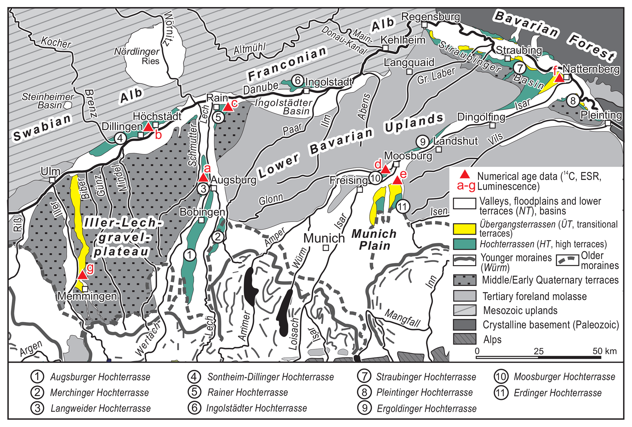
Figure 1Location of Middle Pleistocene (Rissian) Hochterrassen and lower to middle Upper Pleistocene (Würmian) Übergangsterrassen in the Bavarian Alpine Foreland including sampling sites mentioned in the text.
A predominantly sandy gravel unit at the base of coarse-grained and cobble-rich Hochterrassen deposits has been found during geological mapping of the upper Danube valley (Fig. 1: Dillinger Hochterrasse) and in the Lech valley (Fig. 1: Langweider Hochterrasse and Rainer Hochterrasse. Geological maps of these areas including explanations were published by Schellmann (2016b, 2017b) and Schielein and Schellmann (2016a, b). From a lithostratigraphic point of view, these basal gravel units could either be only several hundreds to several thousands years older or even one or more glacial–interglacial periods older than the superimposed penultimate glacial accumulation of the Hochterrassen gravel sensu stricto. In this respect, only numeric dating methods can give a more accurate chronostratigraphical classification.
Numeric dating results are also essential for a geochronological classification of the Jüngere Moosburger Hochterrasse in the Isar valley west of Moosburg (Fig. 1: sample site d). A geological map of this area including explanations has been published by Schellmann (2018b). Here, Nathan (1953) for the first time found sand lenses with an interglacial gastropod fauna like Fagotia acicularis embedded in the Hochterrassen gravel. Therefore, this Hochterrassen deposit is also known by the name “Fagotienschotter” (Fagotia gravel). Whereas Nathan (1953), Brunnacker and Brunnacker (1962), Brunnacker (1966), and Jerz (1993) postulated a last interglacial age, Kovanda (2006) assumed a much older age, older than Mindel.
More numeric age data are also needed for the loess-covered Lower to Middle Würmian Übergangsterrassen (e.g. Doppler et al., 2011, and further references therein). They are older than the pleniglacial (MIS 2) deposition of the oldest Niederterrasse (i.e. NT1), younger than the youngest penultimate glacial Hochterrassen deposits, and younger than the accumulation of the interglacial Jüngere Moosburger Hochterrasse. Übergangsterrassen are well preserved in the Danube valley near Dillingen (e.g. Schellmann, 2017b) and downstream of Regensburg (e.g. Schellmann, 2010), in the Isar valley near Moosburg (Schellmann, 2018b) and at the confluence of the Isar and Danube valley (e.g. Kroemer, 2010; Unger, 1999; Schellmann, 1988) for example.
Samples of ESR dating (snail shells and the surrounding sediment within 30 cm in diameter) and for luminescence dating were collected during geological field mapping of Holocene, Late and Middle Pleistocene fluvial terraces along the Danube, Lech, Wertach and Isar rivers over the past 10 years (Schellmann, 2010, 2016a, 2017a, 2018a).
Shells from land snails were sampled from loamy or marly clods, which were embedded in fluvial gravel and sands of the Langweider and Rainer Hochterrasse (Fig. 1: sample site a and c), of the Dillinger Hochterrasse west of Höchstädt (Fig. 1: sample site b), and of the Jüngere Moosburger Hochterrasse west of Moosburg (Fig. 1: sample site d). These clods were eroded from the adjacent floodplain or from islands in the riverbed during the deposition of the terrace gravels. Shells from gastropods were also collected from the sandy loess cover on the Übergangsterrasse in the Isar valley south of Moosburg (Fig. 1: sample site e), and in the Danube valley west of Natternberg near the Isar–Danube confluence (Fig. 1: sample site f). Luminescence samples were collected and dated from the sandy loess cover on the Übergangsterrasse in the Iller valley northeast of Memmingen (Fig. 1: sample site g). Here, Schaefer (1940, 1953) and Brunnacker (1953) postulated that this loess-covered terrace (named Fellheimer Feld) is older than the Würmian pleniglacial Niederterrasse (named Erolzheimer Feld).
The accuracy of the ESR dating results was checked by parallel dating of two Upper Würmian snail shells by the accelerated mass-spectrometric (AMS) radiocarbon method (Table 1). In addition, at three localities, the ESR data could be compared with luminescence data (Fig. 1: sample sites a, f, g). A further check was made by ESR dating of land-snail shells from different clods of sandy loam, which were embedded in the basal facies of the Dillinger Hochterrasse of the Danube (Fig. 1: sample site b). The composition of the gastropod fauna at some sample sites gave helpful palaeo-ecological information on whether they lived in an interglacial or glacial period. This is also useful to verify the reliability of numeric dating results in general.
Table 1Samples and dose rate data, equivalent doses, ESR ages and AMS radiocarbon data.
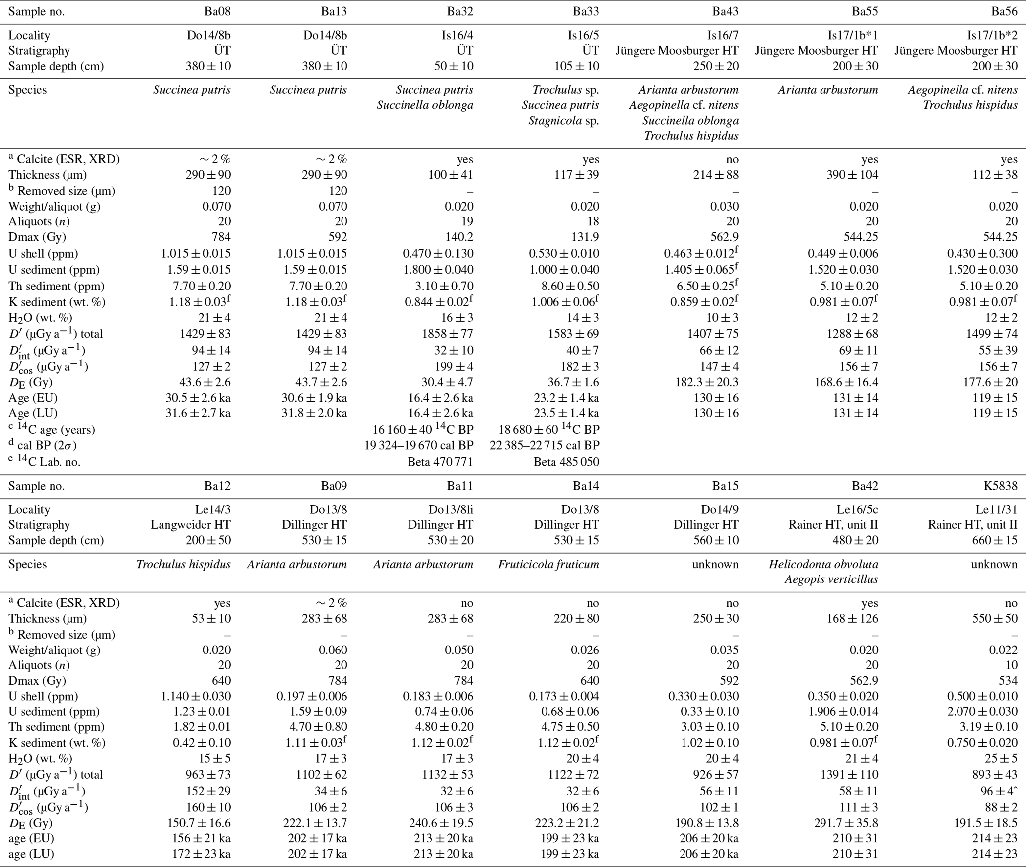
a Calcite (ESR) yes or no indicates with Mn2+ or without Mn2+ lines. b Thickness (µm) reduced by etching with 2 % HCl approximately 1 to 2 min. c AMS 14C ages (Beta Analytic Florida). d Calibrated with IntCal13 (CALIB Rev. 7.0.4); due to hard-water effect the real age is most probably younger than the atmospheric calibrated 14C age. e Beta –Beta Analytic Florida. MAMS – Curt-Engelhorn-Zentrum Archäometrie Mannheim. f Mean value of double or triple analysis; U, Th analysis by ICP-MS, K analyses by ICP-OES or RFA. ESR age calculation uses: k factor of 0.07 ± 0.01 (Grün, 2007; Grün and Katzenberger, 1994); initial 234U∕238U ratio 1.0 ± 0.2; density of shell 2.95 ± 0.02 g cm−3 EU –age calculation assuming early U uptake or LU – linear (continuous) U uptake.
Samples for ESR dating were prepared in the sediment laboratory of the University of Bamberg. After cleaning manually, the thickness of the shell fragments was measured using a micrometer or reflection electron microscope (REM) measurements. REM investigations of some shell thicknesses were undertaken in the laboratory of the Department of Building Preservation Sciences of the University of Bamberg. Both techniques yielded congruent results after having measured the thickness from about 20 points per sample. Afterwards, the shells were carefully ground by hand and sieved with a final grain size of 125 to 250 µm. The ESR signals were measured in the ESR laboratory of the Institute of Geography at the University of Cologne. Due to the small amount of shell material it was necessary to put together a mixture of different individuals to obtain sufficient material for a single sample. In five cases, mixtures of different specimens from one sample site had to be used (Table 1: Ba32, Ba33, Ba42, Ba43, Ba56).
At some locations, particle sizes and carbonate content of the loess cover were determined using the pipette method after Köhn and Köttgen and volumetrically after Scheibler.
3.1 ESR measurements and equivalent dose (DE) calculations
A multiple aliquot additive-dose procedure was applied for ESR DE determination. Depending on the amount of available sample material, 18 to 20 aliquots per sample were used. For sample K5838 material for only 10 aliquots was available. Due to limited sample material each aliquot has a weight between 0.02 and 0.07 g (Table 1) instead of the commonly used 0.2 g. All aliquots were re-weighed after ESR measurement to correct the corresponding ESR signal amplitudes if needed.
All samples were γ-irradiated by a 60Co source (Helmholtz Center in Munich, effective dose rates of 0.8–5.2 Gy min−1) prior to ESR measurements with maximal doses up to 784 Gy for the Middle Pleistocene shells (Table 1).
The ESR measurements were performed at room temperature on a Bruker ESP 300E X-band spectrometer or on a Bruker ELEXSYS 500 X-band spectrometer working at a frequency of 9.7–9.8 GHz. Measurement conditions were microwave power of 10, 25 or 101 mW, modulation amplitude of 0.485 G, conversion time of 20.48 ms, time constant of 163.84 ms and sweep time of 20.972 s. Depending on the individual signal-to-noise ratio, between 5 and 40 scans were used to record the ESR spectra. The DE was derived from the analysis of the dating signal at g=2.0007 (Fig. 2), which was successfully used by Schellmann and Kelletat (2001) in the context of ESR dating of snail shells from aeolianites in Cyprus. The investigated shells are largely composed of aragonite, whereas some shells also contain some calcite layers (Table 1; Fig. 2). Already the smallest traces of calcite (< 2 %) exhibit six triplets of hyperfine Mn2+ lines in the ESR spectra (Fig. 2a; e.g. Low and Zeira, 1972; Molodkov, 1988, 1993; Inoue et al., 2000), which may overlap with the left shoulder of the ESR signal at g=2.0007. In such cases ESR dating is not possible with the method used here. The signal peak at g=2.0007 was determined by additional measurements of a DPPH standard, an aragonitic coral (Acropora palmata) from Cuba and an aragonitic mollusc shell (Protothaca antiqua) from the Patagonian Atlantic coast (Fig. 2b).
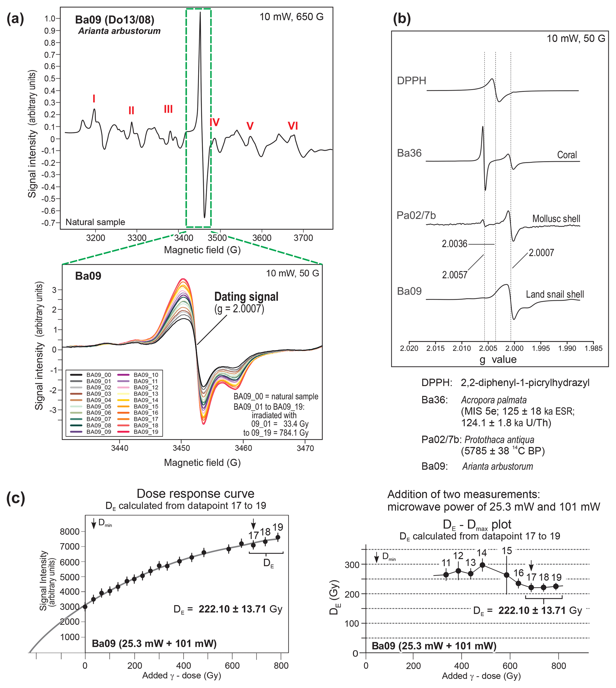
Figure 2ESR spectra of a penultimate interglacial (MIS 7) land-snail shell (Arianta arbustorum) with aragonite and minor calcite crystal structure (calcite content approx. 2 % measured by XRD); (a) ESR screenings with a 650 G (top), and 50 G (bottom) scan width. The latter shows a strong signal growth of the dating signal at g=2.0007 after gamma irradiation to doses of up to 784.1 Gy. The extra-wide ESR screening of 650 G shows six triplets (I to VI) of ESR hyperfine Mn2+ lines in the ESR spectrum; (b) g-value determination of the dating signal of Ba09 using a DPPH, a MIS 5e aragonite coral sample, and a Holocene aragonite mollusc shell for calibration; (c) additive dose response curve and DE–Dmax plot (DDP) of the sample Ba09. Only for this sample, the ESR signal amplitude is the mean value of two separate ESR measurements using different microwave powers of 25.3 and 101 mW, respectively.
The DE–Dmax plot (DDP) procedure was used for DE determination (Fig. 2c). This plateau screening method for DE determination and some further details of ESR measurement parameters, number of aliquots and irradiations steps, timing of major U-uptake processes in mollusc shells and corals have been described in detail by Schellmann and Radtke (1999, 2001), and Schellmann et al. (2008). The DE was calculated using a single saturation exponential function with the program “simplex-fit” (version 1993) written by Rainer Grün.
3.2 Dose rate and age calculations
The natural radioactivity of the surrounding sediments (external dose rate) was determined by measuring the radioactive elements uranium (U), thorium (Th) and potassium (K), and the radioactivity of the snail shells (internal dose rate) by measuring the internal U content. U and Th contents were determined at the Jülich Research Centre and some samples at the Landeslabor Berlin-Brandenburg by inductively coupled plasma mass spectrometry (ICP-MS). The K content was measured at the University of Bayreuth via inductively coupled plasma optical emission spectroscopy (ICP-OES) and partly at the Bavarian Geological Survey via X-ray fluorescence (XRF) analysis. For some samples double analyses of U, Th and K were performed and their mean value was used for ESR age calculations (Table 1). Cosmic dose rates were calculated following Prescott and Hutton (1994) using the current depth of the sample below terrain surface. These estimates were used in the “ESR-Data V-6” software (Grün, 2009) to calculate the age of a sample. The water content of the surrounding sediments was measured in the field using an electronic soil moisture meter. Measured values were used for ESR age calculations with relative errors of 15 % to 30 % (Table 1).
Fortunately, all dated snail shells have low internal U contents, often below 0.5 ppm (Table 1). Thus, ESR ages are the same or do not differ significantly when they are calculated under the assumption of an early (EU) or a linear (LU) U uptake model (Table 1). Even so, mollusc shells seem to incorporate U after death very quickly in a few thousand years (e.g. Schellmann et al., 2008), and consequently ESR age calculation of Pleistocene shells should prefer an early U uptake model, whereas ESR age calculations of Holocene shells should be checked with different U-uptake models.
In the context of ESR age calculation we further used (a) an alpha efficiency (k factor) of 0.07±0.01 following Grün (2007) and Grün and Katzenberger (1994), and we assumed (b) an initial 234U∕238U value of 1.0±0.2, a value commonly found in soils and sediments (e.g. Borylo and Skwarzec, 2014; Vigier and Bourdon, 2012; Srivastava et al., 2012, and further references therein). Weißhaar (2000, Fig. 4.11) for example reported 234U∕238U values of about 0.95 to 1.18 for fluvial gravel, sand, silts and clays in a 280 m deep sediment core of the Quaternary river Neckar alluvial fan deposit (southern Germany).
3.3 Radiocarbon and luminescence data
To check the reliability of the ESR dating results, two Late Würmian snail shells were also dated using the radiocarbon (14C) method (Table 1). Data were calibrated without a hard-water correction using the atmospheric “IntCal13” calibration set (Reimer et al., 2013) and the software CALIB (version 7.0.2; Stuiver and Reimer, 1993). It needs to be considered that the hard-water effect, which may occur as a result of incorporating 14C-free inorganic carbon from dissolved ancient carbonates during shell crystallisation (e.g. Xu et al., 2011, and further references therein), limits the reliability of land-snail 14C age dating results. Measured 14C ages can be a few years, some hundreds of years or even up to 2000 or 3000 years too old (e.g. Goodfriend and Stipp, 1983; Pigati et al., 2010; Xu et al., 2011). In our research area, the river channel and floodplain deposits of the Danube, Isar, and Lech rivers have high carbonate contents; hence 14C ages should be influenced by a hard-water effect of some hundreds of years. This assumption is derived from radiocarbon dates of reworked charcoal or organic plant fragments and associated snail shells in fluvial deposits of the Alpine Foreland rivers Lech (Gesslein, 2013, p. 43) and Danube (Schellmann, 2017b), which have shown age differences of 570 and 500 years, respectively. Since the exact value of the hard-water effect is unknown, the calendar age should be younger than the atmospheric calibrated 14C ages in Table 1.
ESR data are compared to published luminescence dating results from the same or neighbouring outcrops (Kroemer, 2010; Schielein et al., 2015). Additionally, we present two new OSL data (Table 2), sampled from the sandy loess cover on the Übergangsterrasse (i.e.,Fellheimer Feld) in the Iller valley (Fig. 1: sample site g). The luminescence samples were taken from the loess deposits in opaque tubes and prepared under subdued red light in the luminescence laboratory at the University of Bayreuth. Both samples were sieved and treated with 10 % HCl and 10 % H2O2 to remove any carbonates and organic material. The fine-grain (4–11 µm) quartz fraction was segregated by etching with H2SiF6 and enriched by settling using Stokes law. The suspension of demineralised water and 1.5 mg of fine-grain quartz was dispensed onto 9.8 mm wide stainless-steel discs. The measurements for DE estimation were conducted on Risø DA-20 luminescence readers following the standard SAR protocol of Murray and Wintle (2003). OSL emission was filtered through a U-340 filter after stimulation with blue LEDs (125 ∘C, 40 s). The seven or nine measured aliquots of each sample were all accepted and yielded dose values from which median DE values were calculated. For dose rate estimation, uranium and thorium concentrations were measured by alpha-counting and the potassium contents by ICP-OES. Conversion factors from Adamiec and Aitken (1998) were used. Furthermore, the geographic position, recent depth below surface, altitude, and density of the overlying sediment were included in the cosmic dose rate calculations (Prescott and Hutton, 1994) as well as water contents, which were measured in the field considering a relative error of 25 %. Dose rate and age calculations were conducted in ADELE software (Kulig, 2005).
Table 2Samples and dose rate data, equivalent doses, and OSL ages.

4.1 ESR, radiocarbon and luminescence data from the Übergangsterrasse in the Danube, Isar and Iller valley
Ages are obtained from the Upper Würmian sand loess cover on the Übergangsterrasse (ÜT) in the Danube valley north of the Isar valley mouth (Fig. 1: sample site f; Fig. 3 and Table 1: sample Ba33), in the Isar valley near Moosburg (Fig. 1: sample site e; Figs. 4, 5 and Table 1: sample Ba32), and in the Iller valley southwest of Fellheim (Fig. 7: sample site g; Table 2).
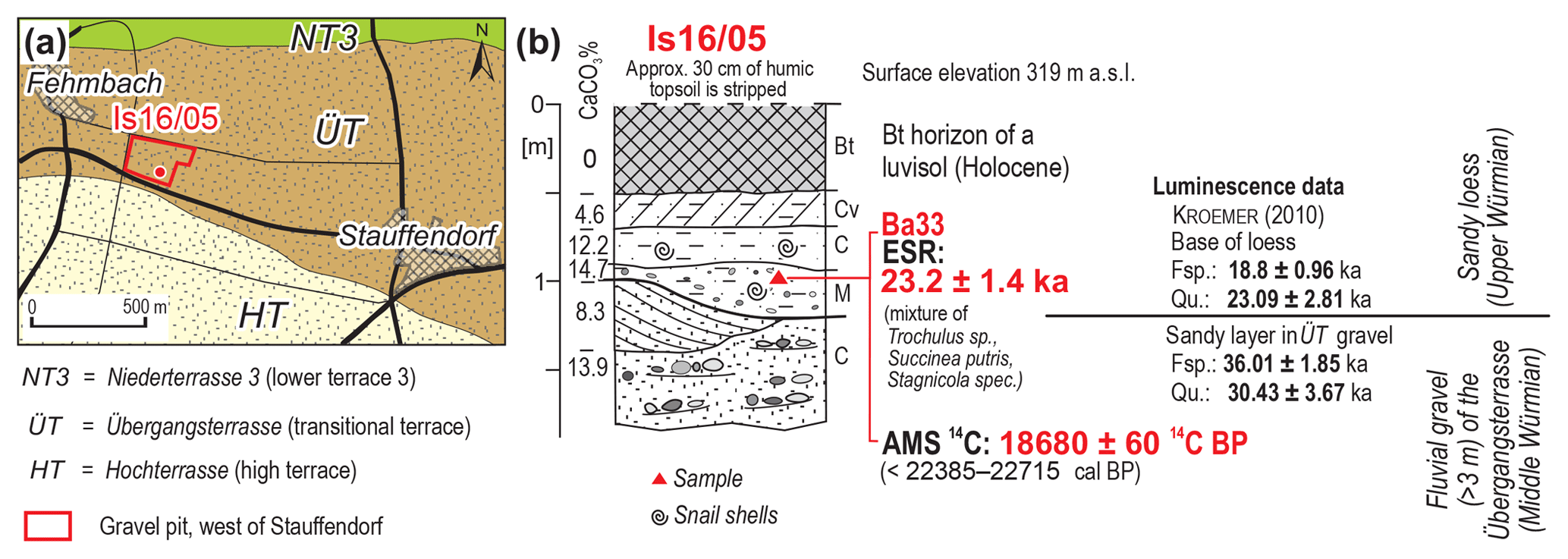
Figure 3ESR, 14C and luminescence data from the Übergangsterrasse in the Danube valley west of the village Stauffendorf; (a) geological map with location of sample site; (b) geological profile with ESR and 14C dating results, and some luminescence data from Kroemer (2010) (Fig. 1: sample site f; Table 1: sample Ba33).
The ÜT in the Danube valley west of the Natternberg was first described by Schellmann (1988, 1990) and Unger (1999), and then later by Kroemer (2010), who published first numeric age data based on luminescence dating of feldspar (Fsp.) and quartz (Qu.) (Fig. 3). The luminescence dating was by Nicole Klasen (University of Cologne). The luminescence data from the base of the loess cover on the ÜT confirm an Upper Würmian (MIS 2) age of around 18.8±1.0 ka (Fsp.) and 23.1±2.8 ka (Qu.). Furthermore, a sandy layer in the fluvial gravel deposits of the ÜT was dated to 36.0±1.9 ka (Fsp.) and 30.4±3.7 ka (Qu.), implying a late Middle Würmian (MIS 3) age of the fluvial aggradations of the ÜT in this area (Kroemer, 2010).
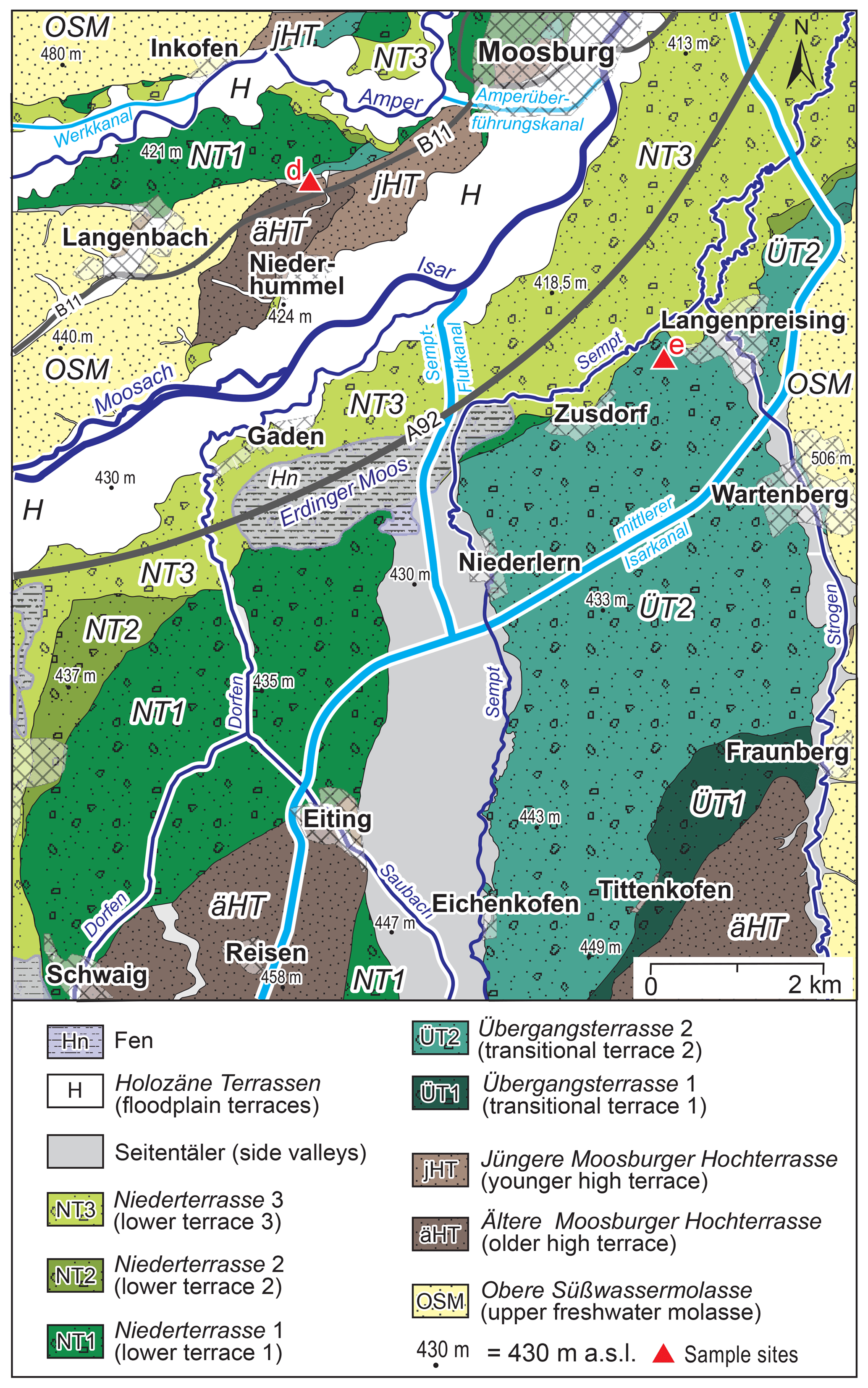
Figure 4Middle and Late Pleistocene terraces of the Isar valley west and south of Moosburg modified after Schellmann (2018b).

Figure 5ESR and 14C dating results of small terrestrial gastropods from the sand loess cover on the Übergangsterrasse 2 west of Langenpreising, Isar valley (Fig. 1: sample site e; Table 1: sample Ba32); (a) geological map modified after Schellmann (2018b) with location of the sample site Ba32; (b) geological profile with dating results and some laboratory analysis (carbonate content, grain sizes); (c) photo of the Übergangsterrassen gravel (left) and its sandy loess cover with sample location Ba32 (right).
In the current study, land-snail shells were sampled from the base of the sandy loess covering the unweathered sandy gravel deposits of the Übergangsterrasse (Fig. 3) and were dated by ESR and 14C. Due to the small amount of shell material, sample Ba33 represents a mixture of the three species Trochulus sp., Succinea putris and Stagnicola sp. (Table 1). The resulting ESR age of 23.2±1.4 ka agrees very well with the quartz age of ca. 23.1±2.8 ka published by Kroemer (2010). Within error, it also agrees well with the AMS 14C age of 18 680 ± 60 BP of the gastropod collected in this study. The atmospheric calibrated age without hard-water correction is about 22 966 to 22 525 cal BP (Table 1: Ba33). If a hard-water effect of a few hundreds of years is assumed, the radiocarbon age would also be within the error range of the ESR age.
Further small terrestrial gastropods for ESR and radiocarbon dating were taken from the gravel pit Schulz in the younger Übergangsterrasse 2 (ÜT2) of the Isar (Fig. 1: sample site e) west of Langenpreising (Figs. 4, 5). Some kilometres south of the location an older Übergangsterrasse (ÜT1) is preserved (Fig. 4), 0.5 to 2 m above the ÜT2. Details about the distribution and stratigraphy of the Übergangsterrassen and other Middle and Upper Pleistocene terraces of the Isar in this region, including some numeric data, are published in Schellmann (2018b). Similar to other valleys of the Bavarian Alpine Foreland, the gravelly, horizontal and occasionally also trough-bedded braided river deposits of the Übergangsterrassen are covered by sandy loess of fine to medium grain sizes (Fig. 5). The upper part of the 7 to 9 m thick gravel deposit of the ÜT2 and its loess cover are exposed in the gravel pit west of Langenpreising (Fig. 5; Table 1: sample Ba32). The calcareous, often sandy loess deposit is between 0.6 and 1.3 m thick and lies on top of the unweathered sandy gravel deposits of the Übergangsterrasse. A fossil palaeo-soil in the form of a very weak Gelic Gleysol and the high content of sandy grain sizes (Fig. 5) are characteristic of many Upper Würmian loess deposits in Bavaria.
An Upper Würmian age of this loess cover is confirmed by the ESR and 14C dating results of land-snail shells. They were sampled from the unweathered sandy loess layers above and below the weak Gelic Gleysol. The sample Ba32 is a mixture of several individuals of the species Succinea putris (Fig. 5; Table 1). The ESR age of 16.4±2.6 ka seems underestimated compared to the atmospheric calibrated AMS 14C age of 19 670–19 324 cal BP. Considering a hard-water effect of a few hundred years, the radiocarbon age would possibly agree with the ESR age within error range.
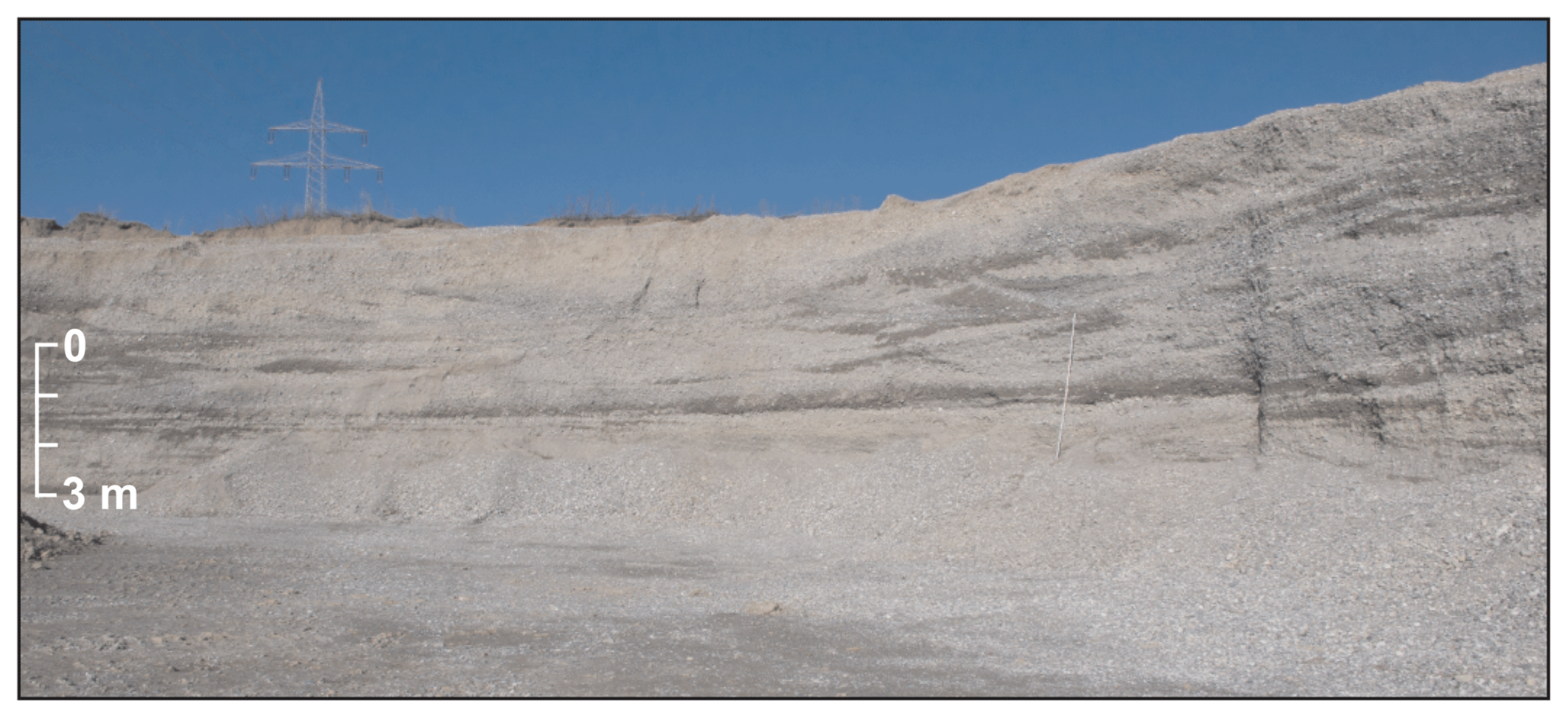
Figure 6Horizontally and trough-bedded gravel deposits of the Übergangsterrasse (Fellheimer Feld in the Iller valley south of the village Fellheim (Fig. 1: sample site g).
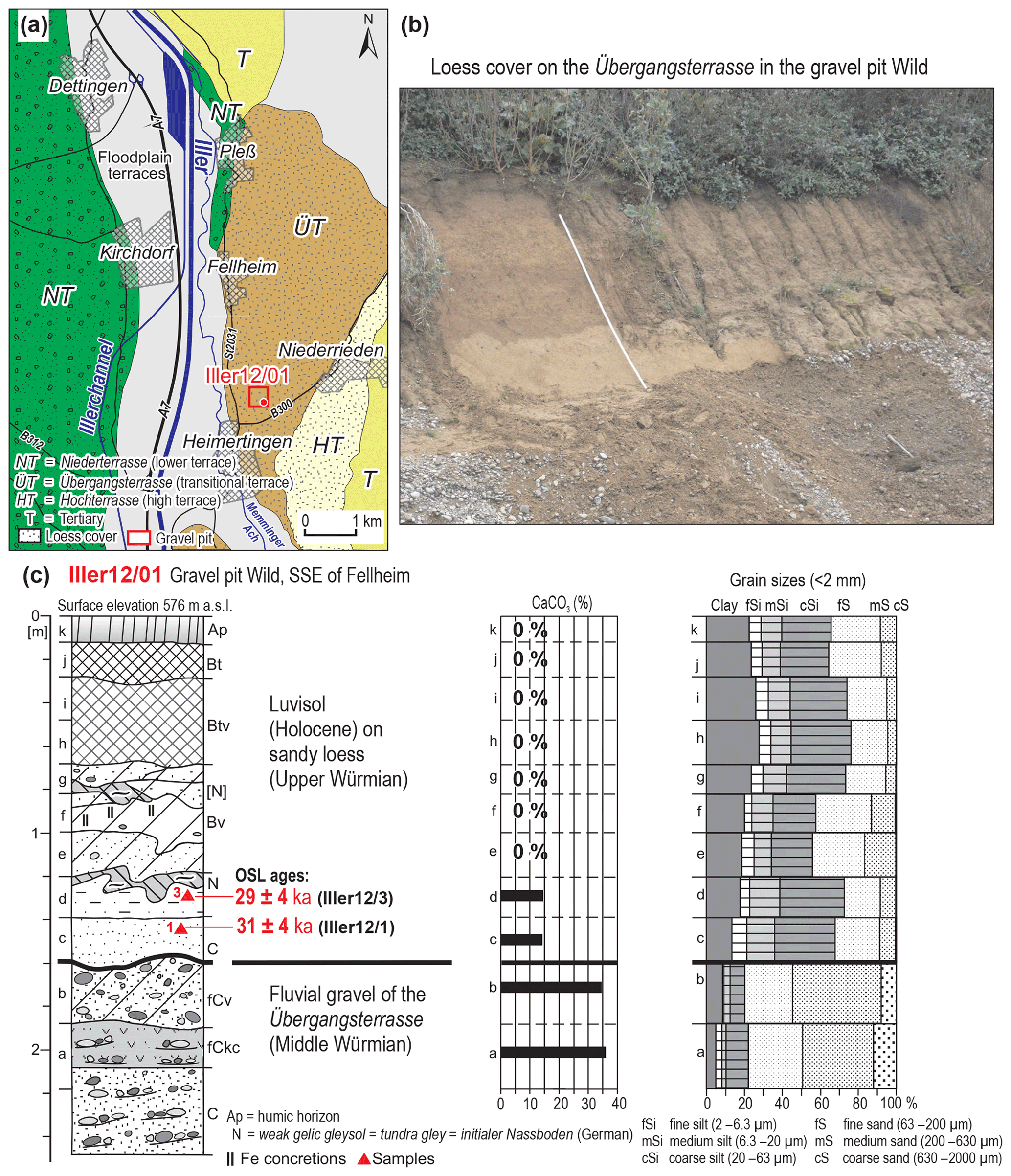
Figure 7Luminescence dating results from the base of the sandy loess cover on top of the Übergangsterrassen gravel south of the village Fellheim (Fig. 1: sample site g; luminescence data are listed in Table 2); (a) geological map with location of the sample site Iller 12/01; (b) photo of the loess cover in the gravel pit Wild; (c) soil profile with some laboratory analysis (carbonate content, grain sizes), and two luminescence ages.
These data from the Übergangsterrassen in the Danube and Isar valley indicate an Upper Würmian age of the loess cover. This is also the case for the loess cover on the Übergangsterrasse in the Iller valley southwest of Fellheim (Fig. 1: sample site g). A formation prior to the Würmian pleniglacial of this loess-covered transitional terrace was first assumed by Schaefer (1940, 1953) and Brunnacker (1953). They demonstrated that the 1 to 2 m, sometimes more than 4 m thick, layers of Würmian loess and loess loam overlay the unweathered gravel deposit without any fossil interglacial soil horizon. In a gravel pit southwest of Fellheim, the more than 10 m thick, horizontally and trough-bedded gravel deposits (Fig. 6: Photo 1) and its up to 1.6 m thick cover of sandy loess (Fig. 7) were recently exposed. Only the upper 20 to 30 cm of the gravel layers were very slightly weathered with some mellow sandstones and dolomites, but without any significant decalcification (Fig. 7). A few species of cold-climate land-snail shells of Succinella oblonga (n=8) and Pupilla muscorum (n=6), and one shell of Cochlicopa lubrica were sampled from the bottom layer of the loess sediments. Unfortunately, not enough material for ESR dating could be sampled. However, two OSL samples of the bottom loess itself yielded ages of 29±4 and 31±4 ka, respectively (Fig. 7, Table 2).
All in all, the fluvial gravel deposits of the described Übergangsterrassen areas in the valleys of the Iller, Isar and Danube rivers are older than the Upper Würmian loess cover on top of their gravel deposits. Most probably, the younger one of the currently known two Übergangsterrassen, the ÜT2, is at least of late Middle Würmian age (MIS 3). This is indicated by the luminescence data of Kroemer (2010) from the Übergangsterrasse of the Danube west of Natternberg (Fig. 3). The age of the older ÜT1 is still unknown. This terrace is younger than the last interglacial Fagotia gravel (see next section), most probably of Early Würmian age (MIS 5d to MIS 4).
4.2 ESR data and gastropod fauna from the Jüngere Moosburger Hochterrasse (Fagotienschotter, Isar valley)
Two different levels of Hochterrassen are preserved between the Isar and lower Amper valley in the vicinity of Moosburg (Fig. 4) and were described in detail by Schellmann (2018b). The Ältere Moosburger Hochterrasse (Older Moosburger high terrace) is elevated about 15 to 16 m above the floodplain of the river Isar, the Jüngere Moosburger Hochterrasse (Younger Moosburger high terrace) about 10 to 14 m.
The fluvial gravel deposits of both Hochterrassen have thicknesses of about 5 to 7 m, which are covered by Würmian loess mostly with thicknesses of 1 to 5 m. The Middle Pleistocene gravel deposits underlying the Hochterrassen are elevated above the fluvial gravel deposits of the adjacent Würmian and Holocene terraces of the Isar valley.
The Jüngere Moosburger Hochterrasse is situated between the valleys of Isar and Amper (Fig. 4). This terrace deposit has been known for many years under the name Fagotienschotter (Fagotia gravel), named after the gastropod Fagotia acicularis. Biostratigraphically (mollusc content) these gravel deposits are supposed to be as old as the last interglacial (Nathan, 1953; Brunnacker and Brunnacker, 1962; Brunnacker, 1966; Jerz, 1993) or older than the Elsterian glaciation in northern Germany as postulated by Kovanda (2006). All these authors agree on the interglacial habitus of the gastropod fauna; only the age interpretation is controversial.
Gastropod samples for dating were collected from a small gravel pit west of Moosham (Fig. 1: sample site d; Fig. 8). Here, marly clods bearing land-snail shells are intercalated in the Fagotienschotter. This new collection of land-snail species is similar to the collection of Nathan (1953). The interglacial character of the gastropod fauna is demonstrated by some interglacial species like Aegopinella nitens and by some further species that prefer warm temperate climatic conditions (Table 3). The floodplain of the river Isar, containing small standing waters and swamps and rich in high shrubs, could have been the habitat from which the snails derive. Species indicating dryness or open landscapes are almost completely absent.
Table 3Shells from gastropods collected from sand lenses and clods of marl and sand embedded in the Jüngere Moosburger Hochterrassen gravel (Fagotia gravel).
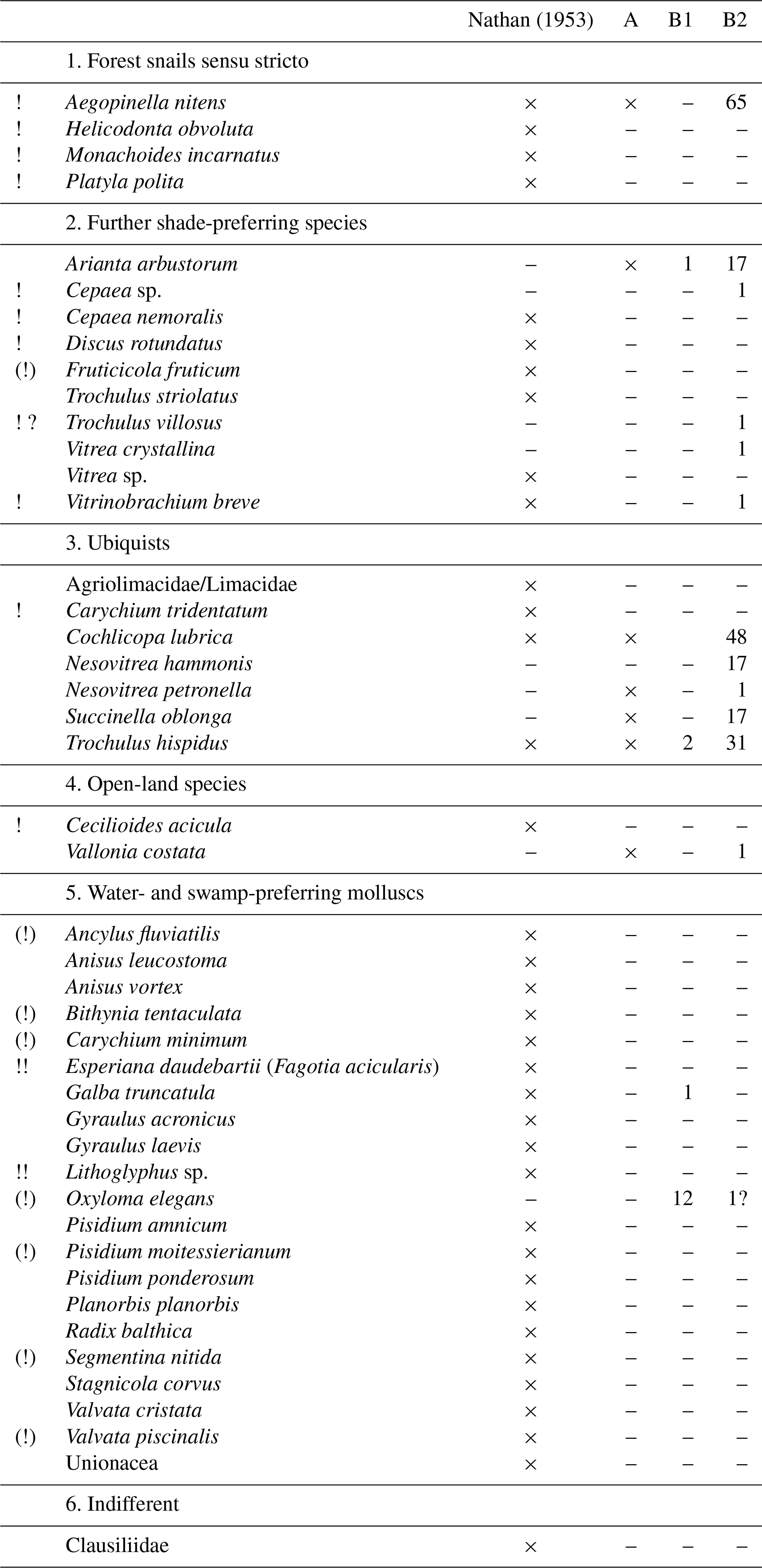
A – sample Is 16/97 collected 2016; B1 – sample Is 17/1a collected 2017; B2 – sample Is 17/1b collected 2017 in the gravel pit west of Moosham. !! interglacial indicator species: ! interglacial species; (!) predominately warm temperate species, sometimes also distributed in interstadials.
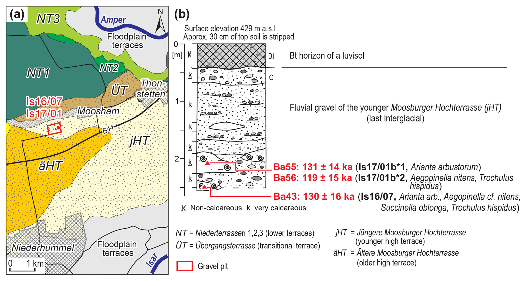
Figure 8Marly and fine-sandy clods in the gravel deposits of the Jüngere Moosburger Hochterrasse (Fagotia gravel) west of Moosham, Amper valley (Fig. 1: sample site d; Table 1: samples Ba43, Ba55, Ba56). Small gastropods were collected and ESR dated from two separate clods in the years 2016 (sample Is16/07, Ba43) and 2017 (sample Is17/1, Ba55, Ba56); (a) geological map (modified after Schellmann, 2018b) with location of sample sites; (b) soil profile with ESR dated gastropod shells (species are listed in Table 3).
Land-snail shells were collected from two separate marly clods (Fig. 8: Is 16/7 and Is17/1b) and dated by ESR. A mixture of land-snail shells of the species Aegopinella cf. nitens, Arianta arbustorum, Succinella oblonga and Trochulus hispidus yielded a last interglacial ESR age of 130±16 ka (Table 1: Ba43). In the other marly clod, a few individuals of Arianta arbustorum also resulted in a last interglacial ESR age of 131±14 ka (Table 1: Ba55) and a shell mixture of Aegopinella cf. nitens and Trochulus hispidus in an ESR age of 119±15 ka (Table 1: Ba56).
From a morphostratigraphic point of view, the Jüngere Moosburger Hochterrasse (or Fagotia gravel) is older than both Übergangsterrassen deposits of Lower to Middle Würmian age southwest of Moosburg. And it also is younger than the Rissian Ältere Moosburger Hochterrasse, which is preserved in the west of the Jüngere Moosburger Hochterrasse (Fig. 4; details in Schellmann, 2018b). The gastropod fauna, which is preserved in marly or sandy clods or in sand lenses in the gravel deposits of the Jüngere Hochterrassen, indicates a warm temperate interglacial age of this deposit (Nathan; 1953, Brunnacker and Brunnacker, 1962; Brunnacker, 1965; Kovanda, 2006); the three ESR ages provide clear evidence for a deposition during the last interglacial (MIS 5e).
4.3 ESR data and gastropod fauna from the basal gravel unit of the Dillinger Hochterrasse
In the Danube valley between the villages Sontheim, Dillingen and Höchstädt (Fig. 9), Hochterrassen are widely preserved, especially north of the river. Graul (1962) was the first one to separate this extensive Hochterrassen area into three sublevels, and Leger (1988) and Bibus and Strahl (2000) found that the middle level of these three Hochterrassen levels, the Dillinger Hochterrasse, is composed of two stacked gravel deposits. This is the case in areas where the otherwise typically 5 to 8 m thick Dillinger Hochterrassen gravel reaches unusual thicknesses of about 10 to 13.5 m (Fig. 9). For details about the Dillinger Hochterrasse including the history of research, a geological map and a revised fluvial terrace stratigraphy of the Danube valley in this region, see Schellmann (2017a, b).
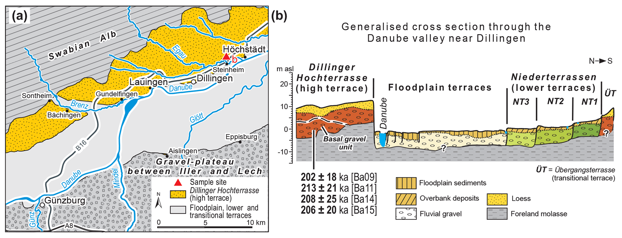
Figure 9Distribution (a) and geological cross section (b) of the Dillinger Hochterrasse on the northern valley side of the river Danube between the villages Sontheim, Dillingen and Höchstädt (modified after Schellmann, 2017b).
Like the Fagotienschotter in the Isar valley, the basal gravel formation of the Dillinger Hochterrasse in the Danube valley west of Höchstädt (Fig. 1: sample site b, Fig. 9) also contains a warm-temperate interglacial mollusc fauna, which is embedded in sandy layers and predominantly in loamy and sandy clods. It was Leger (1988) who for the first time described an interstadial or interglacial gastropod fauna embedded in sandy gravel deposits of the Dillinger Hochterrasse west of the village of Höchstädt.
Table 4Shells from gastropods collected from sandy gravel deposits of the Dillinger Hochterrasse in the eastern part of the gravel pit Höchstädt.
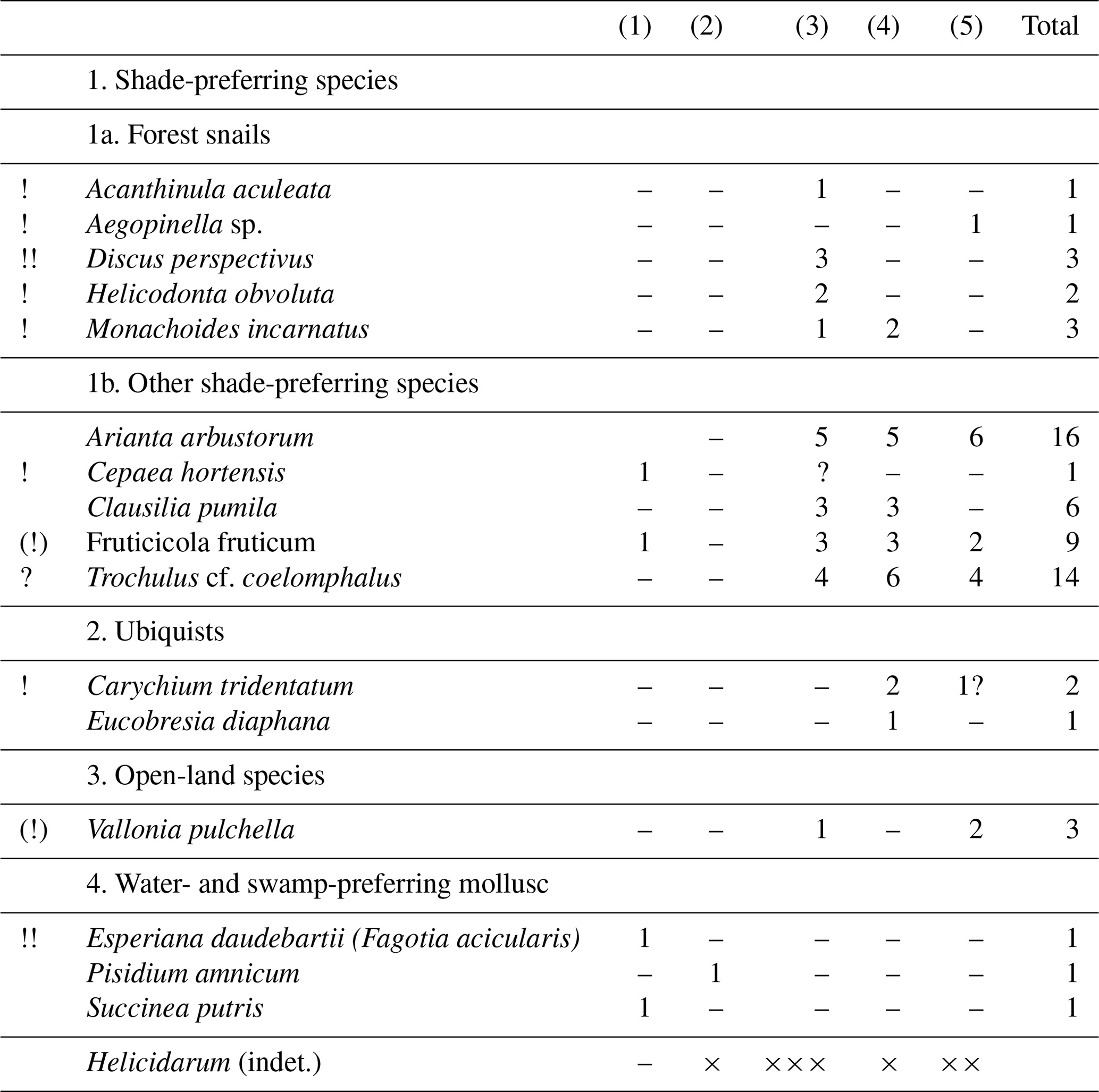
!! interglacial index species ! interglacial species (!) predominately warm temperate species. (1) gastropods collected from sandy layer during July 2013. (2) gastropods collected from sandy layer during October 2013 (Do 13/5). (3) gastropods collected from a loamy and sandy clod during October 2013 (Do 13/8li). (4) gastropods collected from another loamy and sandy clod during October 2013 (Do 13/8re). (5) gastropods collected from both loamy and sandy clods during October 2013 (Do 13/8).
Gastropods shells have been collected from sandy layers and loamy and sandy clods at different sections in a gravel pit on the Dillinger Hochterrasse west of Höchstädt (Fig. 10). This location is only some hundred metres away from the site sampled by Leger (1988). The clods were deposited in frozen state in the basal gravel formation of the Dillinger Hochterrasse and have been reworked from a nearby former floodplain. Only in the eastern part of the gravel pit, this large-scale cross-bedded basal gravel unit reaches up to the gravel surface below the last glacial (Würmian) loess cover (Fig. 10b). In most parts of the gravel pit, the basal gravel unit is overlain by another few-metres-thick gravel unit deposited by a braided river (Fig. 10c). Gastropod shells were sampled in the eastern part of the gravel pit from two sandy layers (Table 4) and from two loamy and sandy clods (Fig. 10b). The collected gastropod fauna contain a few interglacial index species like Discus perspectivus and Esperiana daudebartii (Fagotia acicularis) and some other warm temperate species like Helicodonta obvoluta and Monachoides incarnatus (Table 4).
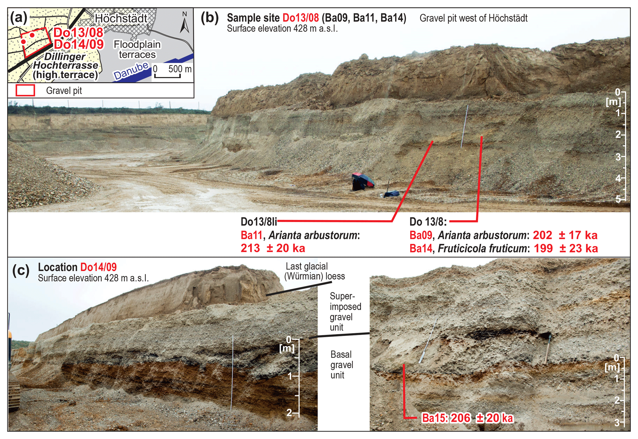
Figure 10ESR dating results of an interglacial gastropod fauna from the basal gravel unit of the Dillinger Hochterrasse in the gravel pit Höchstädt W (Fig. 1: sample site b; Table 1: samples Ba09, Ba11, Ba14, Ba15); (a) geological map (modified after Schellmann, 2016b) with location of sample sites Do13/8 and Do14/9; (b) photo of sample site Do13/8 and ESR ages of the samples Ba09, Ba11, Ba14; (c) photos of the location Do14/9 with a large scale cross-stratified basal gravel unit and a horizontally bedded (braided river) top gravel unit (left), and the location and ESR age of sample Ba15 (right).
ESR dating of Arianta arbustorum (Ba09) and of Fruticicola fruticum species (Ba14) gave almost identical ages of 202±17 and 199±23 ka, respectively (Fig. 10b: Do13/8; Table 1: Ba09 and Ba14). The ESR age of 213±20 ka of a further Arianta arbustorum shell from a neighbouring clod of loamy sand in this part of the gravel pit is within the error range of the other ages from this gravel unit (Fig. 10b: Do13/8li; Table 1: Ba11). Gastropod shells from the western part of the gravel pit (Fig. 10c: Do14/9, Ba15; Table 1: Ba15) also yield a MIS 7 age of 206±20 ka. This shell-bearing clod was also deposited in the sandy and large-scale cross-bedded basal gravel unit. The overlying unit of a medium- to coarse-gravel facies is horizontally bedded, which is typical of braided river deposits. This overlying gravel unit was deposited by the Danube under cold climate conditions most probably during MIS 6. Under warm climate conditions like the Holocene the Danube is a meandering river in this region with sandy gravel channel deposits, which are large-scale cross-bedded (Schellmann, 2017b).
In general, these ESR dating results from the Dillinger Hochterrasse illustrate that ESR ages of different species of land-snail shells and from different clods of sandy loam in a gravel pit yield highly congruent ages. All ESR data from the basal gravel unit in the gravel pit west of the village Höchstädt are of penultimate interglacial (MIS 7) age. These dating results confirm the regional stratigraphy (Schellmann, 2017b) and match the warm temperate climate indicated by the gastropod species. The 2 to 5 m thick superimposed gravel unit with its braided river facies type is most probably of penultimate glacial age (Rissian, MIS 6).
4.4 ESR and luminescence data from the Langweider Hochterrasse (Lech valley)
Similar to the Dillinger Hochterrasse in the Danube valley, a subdivision of the Middle Pleistocene fluvial gravel deposits of the Langweider Hochterrasse between Lech and Schmutter valley in two different gravel formations has been discussed for decades (Schäfer, 1957; Scheuenpflug, 1979, 1981; Aktas and Frechen, 1991; Schellmann, 2016b; Schielein and Schellmann, 2016a). All these studies assume a deposition of the 6 to 8 m thick top unit of the Langweider Hochterrasse during the penultimate glacial (Rissian), whereas the age of the basal gravel unit with thicknesses of 2 to 4 m remained uncertain. It was Schielein et al. (2015) who presented first luminescence data from both gravel units (Fig. 11) and one ESR age from the basal gravel deposit (Fig. 11: Le 11/26c; sample site: A11 Nachwegäcker). The luminescence data indicate a Rissian age of the superimposed gravel. Four IRSL samples from the basal gravel unit imply an age older than MIS 6, whereas the ESR dating of one large shell of Succinea putris refers to a deposition during the penultimate interglacial (MIS 7).
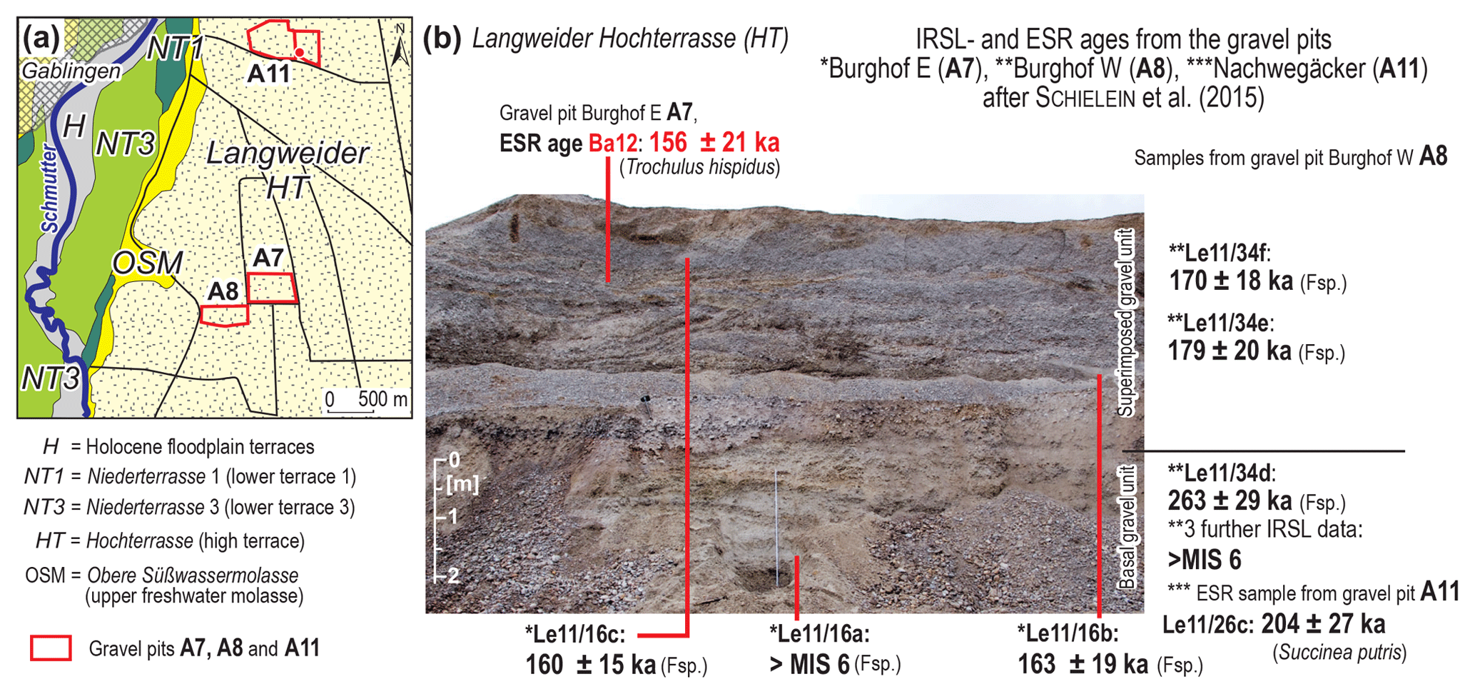
Figure 11ESR and luminescence data from the stacked gravel deposits of the Langweider Hochterrasse in the gravel pit A7 Burghof E (Fig. 1: sample site a); (a) geological map (modified after Schellmann, 2018b; Schielein and Schellmann, 2016a) with location of sample sites; (b) photo with the newly dated ESR sample Ba12, and with some luminescence and ESR ages from Schielein et al. (2015). The latter are from the same outcrop (*), or from the nearby gravel pits A8 Burghof W (**) and A11 Nachwegäcker (***).
Small shells of the land-snail species Trochulus hispidus were collected from a clod of marl in the superimposed gravel (Fig. 11: sample site A7; Table 1: sample Ba12). The ESR age of 156±21 ka is similar to IRSL ages of 160±15 ka and of 163±19 ka from sandy layers in the same gravel unit. Within error range, the ESR and luminescence ages also fit to two IRSL dates of 170±18 and 179±20 ka from the superimposed gravel in the neighbouring outcrop A8 Burghof W (Fig. 11). It can be stated that the superimposed gravel of the Langweider Hochterrasse was most likely accumulated during the penultimate glacial (MIS 6, Rissian), whereas the basal gravel unit has a minimum age of MIS 7 (Schielein et al., 2015). Most probably, the basal gravel formation may be correlated with the basal gravel deposit of the Dillinger Hochterrasse.
4.5 ESR and luminescence data from the Rainer Hochterrasse and from its loess cover (Lech valley)
Following the Lech valley downstream, a further high terrace is conserved near the confluence of Lech and Danube rivers: the Rainer Hochterrasse (Fig. 1: sample site c; Fig. 12). In contrast to Schaefer (1966), a clear morphostratigraphic subdivision of the Rainer Hochterrasse could not be confirmed (Schielein and Schellmann, 2016b) as already stated by Kilian and Löscher (1979). Only small areas of the significantly lower elevated surfaces of the Übergangsterrasse can be differentiated from the higher elevated areas of the Rainer Hochterrasse (Fig. 12).
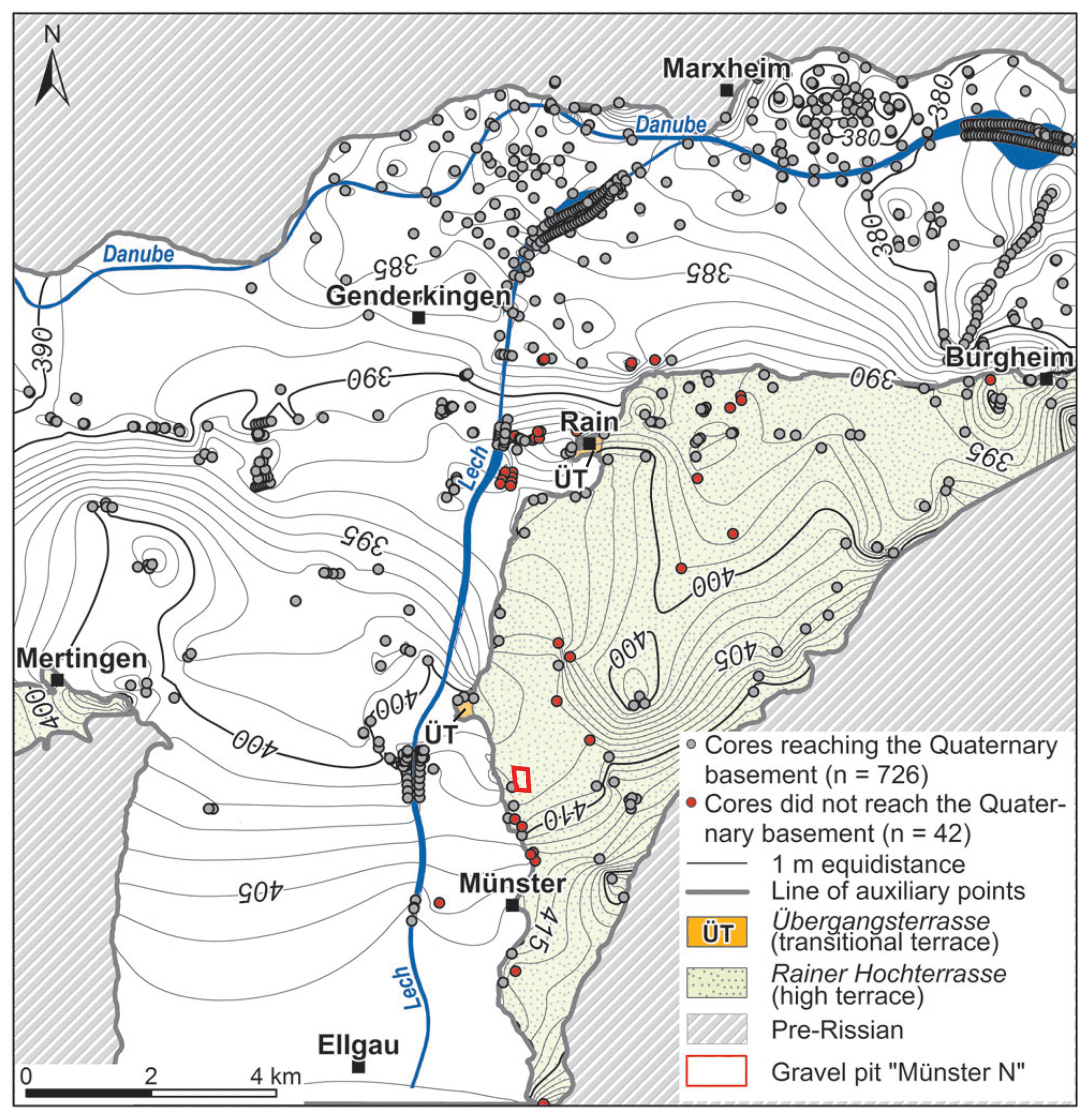
Figure 12Geological map of the Rainer Hochterrasse with contour lines of the base level (m a. s.l.) of the Quaternary gravel deposits and location of the gravel pit Münster N mentioned in the text.
The uniform terrace level of the Rainer Hochterrasse including some periglacial dry valleys is elevated about 10 to 14 m above the valley floor of the Lech and Danube rivers and its Würmian and Holocene terraces. The gravel deposits and the 1 to 3 m thick loess and sand loess cover reach thicknesses of 7 to 13 m in total. The base of the gravel deposits in the area of the Rainer Hochterrasse is about 8 to 10 m higher than the base level in the adjacent Upper Würmian and Holocene valley bottom (Fig. 12). In a southwest–northeast-orientated elongated depression extending in the central areas of the high terrace, a maximum thickness of the Quaternary sediments up to 15 m is reached (Fig. 12; Kilian and Löscher, 1979).
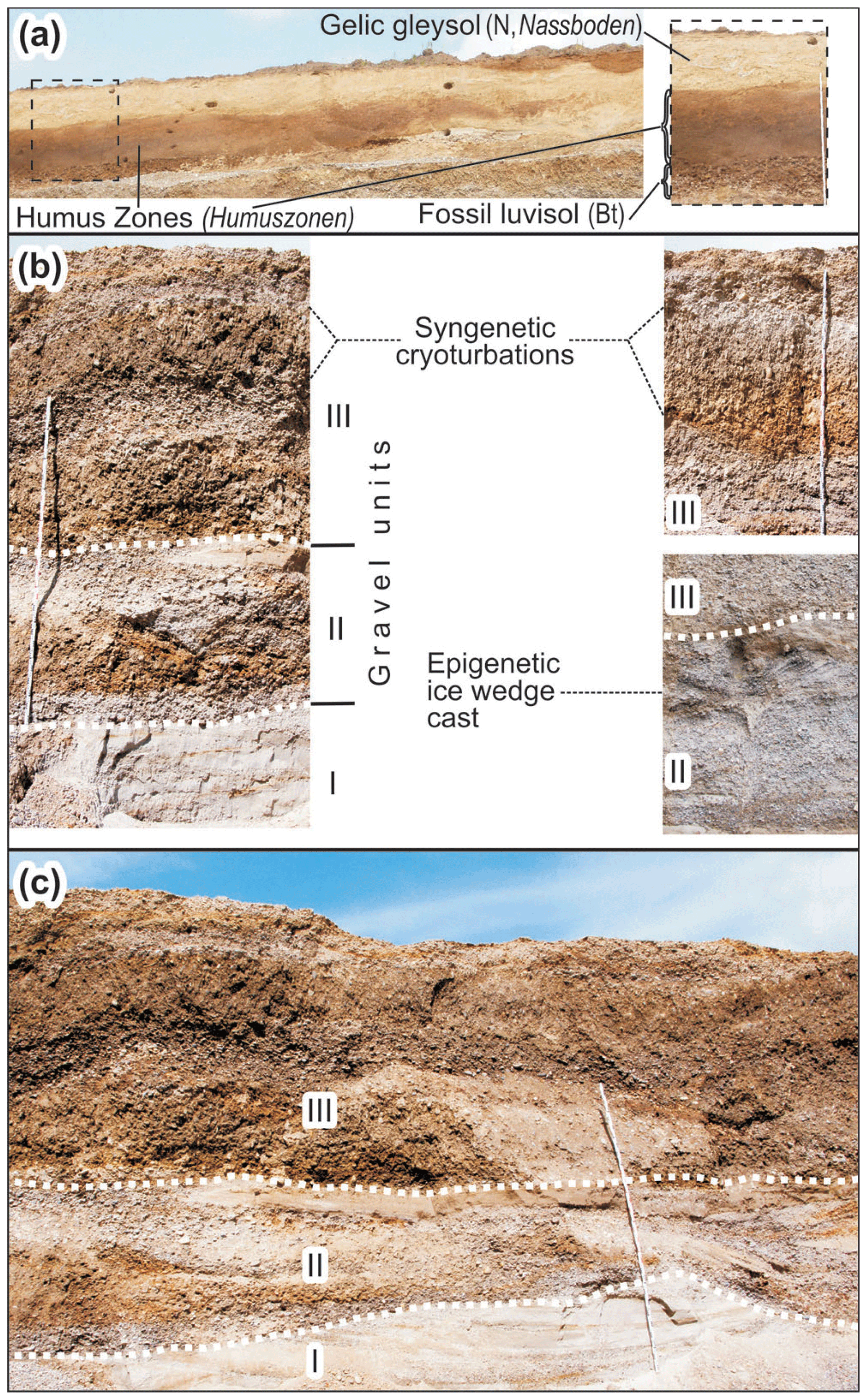
Figure 13Images of the different fluvial gravel deposits of the Rainer Hochterrasse and the Würmian loess cover exposed in the gravel pit Münster N (Fig. 1: sample site c) during the last few years; (a) images of the loess cover exposed during the year 2009; (b) images of the three gravel units I to III exposed during the years 2016 and 2017; (c) image of the three gravel units I to III exposed during the year 2017.
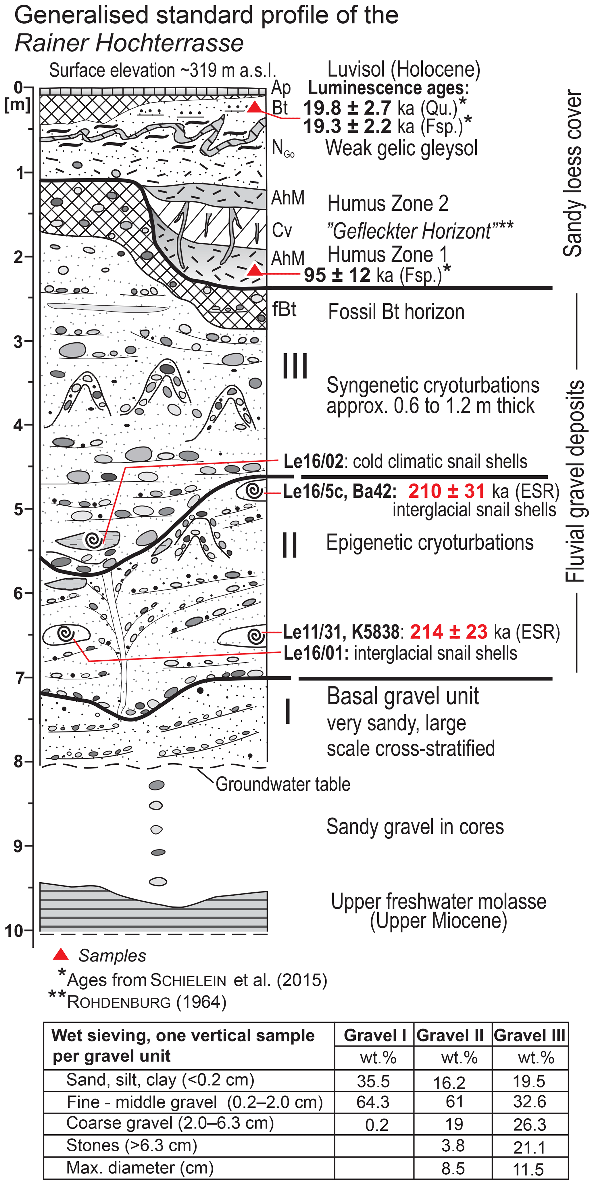
Figure 14Generalised standard profile of the different sediment units of the Rainer Hochterrasse exposed in the gravel pit Münster N (Fig. 1: sample site c) during the last few years. IRSL data from the loess cover are from Schielein et al. (2015); the ESR dating results of an interglacial gastropod fauna from the gravel unit II and the faunae collections are new.
In one gravel pit north of the small village of Münster (gravel pit Münster N), which has been investigated by different researchers (e.g. Tillmanns et al., 1982, 1983; Schielein et al., 2015; Schielein and Schellmann, 2016b), the following summarised section has been exposed since 2016. Here, the Hochterrassen gravel is covered by 1 to 2.5 m thick loess sediments. In periglacial depressions, some decimetres thick layers of solifluidal reworked silts, sands and gravels (Fig. 14) are present. Up to three slightly rusty and grey Gelic Gleysols (tundra gley, Nassboden) may be preserved in the upper part of the fine-sandy loess cover. Similar weak Gelic Gleysols are most common in Upper Würmian loess deposits in Germany. In the lower part of a 2.6 m thick fine-grained infill of a periglacial trough valley, a stack of two humic horizons (Humuszonen) was preserved (details in Schielein and Schellmann, 2016b), which are comparable to the Lower (Early) Würmian Mosbacher Humuszonen (e.g. Semmel, 1968). Light reddish-brown spots in the upper part of the lower humic horizon correlate most probably to the “gefleckten Horizont” (spotted horizon) of Rohdenburg (1964) and might have been developed through acidic conditions by bleaching along plant roots. The Upper to Lower Würmian age of this loess cover is confirmed by the luminescence ages of 19.3±2.2 ka (Fsp.) and 19.8±2.7 ka (Qu.) from the top of the sandy loess cover, and of 95±12 ka (Fsp.) from the base of the lower humic horizon (Fig. 14; Schielein et al., 2015).
Below the loess cover, a fossil interglacial soil horizon (Bt horizon of a Luvisol; Fig. 14) with a mean thickness of 0.3 to 0.5 m is widely preserved on top of the high terrace gravels. In several outcrops, the 8 to 14 m thick sandy gravel deposits of the Rainer Hochterrasse can be subdivided into two stacked gravel units as previously mentioned by Tillmanns et al. (1982, 1983) and Schielein et al. (2015). In the aforementioned gravel pit Münster N, a third gravel unit is exposed below the other units near the groundwater table (Fig. 13). This very sandy and often large-scale cross-bedded or sometimes trough-bedded gravel unit I is often preserved approximately up to 1 to 2 m above the groundwater level (Fig. 14). The light colour of unit I is due to its high sand content of about 35 % and allows a clear separation from both superimposed gravel units, whose sand content is significantly lower (Fig. 14). The more than 1.5 m thick gravel unit II is predominately composed of fine to medium gravels but may contain coarse- and medium-sand layers with thicknesses of up to 1 m (Schielein et al., 2015). Sometimes epigenetic cryoturbations or small ice-wedge casts (Fig. 13) are preserved at the top of the gravel unit II. These periglacial features are overlain discordantly by the 2 to 5 m thick gravel deposits of unit III. The latter consists of medium and coarse gravel with many stones in a sandy matrix (Fig. 14), shows horizontal and trough-bedding, and exhibits strong syngenetic cryoturbations within the upper part of the unit (Fig. 13) as already described by Tillmanns et al. (1982, 1983).
In general, gravel units I and II are both large-scale cross-bedded, which indicate a deposition by a meandering or a moderate branching river like the Holocene river Lech. In contrast, the superimposed gravel unit III was accumulated by a braided river as it is characteristic of river morphology in this region under Pleistocene cold climate conditions.
Single clods of marl or sand can be preserved from the groundwater level up to the top of the gravel deposits. A separation of the whole gravel deposit by one significant layer of marly clods (“Mergelbatzenhorizont”) as described by Tillmanns et al. (1982, 1983) was not comprehensible. All gravel units contain marly or loamy clods sometimes concentrated near the base of a gravel unit but often irregular within the gravel unit. As already described by Tillmanns et al. (1982, 1983) these clods sometimes contain shells of predominately cold (Columella columella, Pupilla muscorum, Succinea oblonga, Trichia hispida) and rarely warm (Ena montana, Discus rotundatus, Aegopinella sp., Helicondonta obvoluta, Cepaea sp.) gastropod fauna. A cold climatic or interstadial gastropod fauna could be sampled from a marly clod embedded at the base of gravel unit III at approx. 5.5 m below terrace surface (Fig. 14: Le16/2). This clod contained shells from the following species: Cochlicopa lubrica, Pupilla muscorum, Neostyriaca corynodes, Succinella oblonga, Trochulus hispidus, Vallonia costata and Vallonia pulchella. Shells from Cochlicopa lubrica, Pupilla muscorum, Succinella oblonga, Vallonia costata and Vallonia pulchella have been sampled also from marly clods with cold climatic gastropod fauna in 5 to 6 m below terrace surface by Tillmanns et al. (1982).
Both the cold climatic habitus of the gastropod fauna and the strong syngenetic cryoturbations clearly point to a deposition of gravel unit III under periglacial, stadial or interstadial climatic conditions older than the Early to Late Würmian loess and older than the interglacial Bt horizon on top of the gravel deposits. The upper gravel unit is most probably of penultimate glacial (Rissian, MIS 6) age.
In contrast, two loamy clods from gravel unit II contain interglacial fauna. The following warm temperate species could be sampled from a loamy clod from gravel unit II in 4.8 m below surface (Fig. 14: Le16/5c): Aegopis verticillus, Cepaea sp. (nemoralis?), Cochlodina laminata, Helicodonta obvoluta, Isognomostoma isognomostomos and Monachoides incarnatus. A further loamy clod from gravel unit II in a depth of 6.5 m below surface contains shells of the warm temperate species Aegopinella sp., Helicodonta obvoluta, and Monachoides incarnatus (Fig. 14: Le16/1). These species have already been sampled by Tillmann et al. (1982) in this outcrop area from a marly clod with warm climatic gastropod fauna at approx. 5 m below terrace surface.
Helicodonta obvoluta and Aegopis verticillus shells from a loamy clod (Fig. 14: Ba42) and one large shell fragment from a layer of fine-sandy loam (Fig. 14: K5838) yielded almost identical ESR ages of 210±31 and 214±23 ka, respectively. Hence, the formation of gravel unit II during penultimate interglacial (MIS 7) is very likely. Schielein et al. (2015) published four luminescence (IRSL, OSL) ages from one sand layer at the top of gravel unit II in a nearby gravel pit, but the data scatter between MIS 7 and MIS 9.
The age of the underlying gravel unit I is still open. It could have been deposited under warm climate conditions as indicated by the sedimentological observations, perhaps during the MIS 7 interglacial period.
Numerical age data (ESR, OSL, 14C) indicate that the formation of the two Übergangsterrassen (ÜT1, ÜT2) in the Bavarian Alpine Foreland took place before the Upper Würmian (MIS 2) and thus before the formation of the oldest Niederterrasse 1 (NT1) and the loess accumulation on top of the fluvial gravel deposit during MIS 2 (Table 5). In the valley of the river Isar in the vicinity of the village of Moosburg, it could be shown by geological mapping that both Übergangsterrassen are younger than the Jüngere Moosburger Hochterrasse (i.e. Fagotia gravel) of MIS 5e age. Luminescence data by Kroemer (2010) from a sandy layer in the fluvial gravel deposit of the ÜT2 in the Danube valley west of the Natternberg imply a late Middle Würmian age (MIS 3). This correlates well with the fact that only Upper Würmian loess covers the Übergangsterrassen gravel. Previously, Buch and Zöller (1990; see also discussion by Schellmann, 2010) published early Upper Würmian luminescence ages of 25.4±2.4 and 24.1±2.4 ka respectively from the base of the loess cover on the younger Übergangsterrasse (ÜT2; Schellmann, 2010) of the Danube southeast of Regensburg (Fig. 1). Buch and Zöller (1990) called this loess-covered terrace level “Deckniveau der Niederterrasse”.
Table 5Stratigraphical overview for the formation of Middle and Upper Pleistocene gravel deposits in the Bavarian Alpine Foreland.
In contrast to the younger Übergangsterrasse (ÜT2), the age of the older ÜT1 is still unknown. But the ÜT1 is younger than the MIS 5e old Jüngere Moosburger Hochterrasse. Therefore, the ÜT1 is most likely of Early Würmian age (MIS 5d to MIS 4). Doppler et al. (2011, p. 354) assume that the relatively young OSL data of ∼70 to ∼90 ka by Fiebig and Preusser (2003) for parts of the Rainer Hochterrasse, for the Neuburger as well as the Ingolstädter Hochterrasse most likely point to a classification as Übergangsterrasse.
At this point, a short but stratigraphically important digression to northern Germany may be excused. In the Upper Weser valley between the villages of Hamelin (Hameln in German) and Rinteln, an Übergangsterrasse is preserved (Schellmann, 1994). The terrace is younger than the Drenthe glaciation (MIS 6; Lang et al., 2018) of the valley and older than the Upper Weichselian (Upper Pleistocene) Niederterrasse 1. At the gravel pit Franke (geological map in Schellmann, 1994: Fig. 6), Winsemann et al. (2015) postulated on the basis of one luminescence dated sample (79±3 ka) a loess-covered lower middle terrace (Untere Mittelterrasse), which can likely be correlated to the Übergangsterrasse mapped by Schellmann (1994) in this area.
Until now, the only known terrace of last interglacial age in the Bavarian Alpine Foreland was the Jüngere Moosburger Hochterrasse (Fagotia gravel). The interglacial formation of this gravel deposit has been known for many years by the finding of shells from interglacial gastropod fauna embedded in sand lenses and loamy clods. They were described first by Nathan (1953), Brunnacker and Brunnacker (1962), and Brunnacker (1965). The ESR data (Table 1) of three shell samples with ages of 131±14, 130±16 and 119±15 ka point to a last interglacial (MIS 5e) age of this terrace (Table 5) instead of an age older than the Elsterian glaciation in northern Germany as postulated by Kovanda (2006).
Generally, the Hochterrassen in the Bavarian Alpine Foreland were formed under cold climatic conditions during the Rissian period. Therefore, they are covered by loess sediments of Würmian age only, and just a relict of one interglacial soil (Bt horizon of a Luvisol) may be preserved at the top of their fluvial gravel deposits. Most recently, Mayr et al. (2017) published new numeric age data with Würmian ages from the loess cover and its palaeosoils preserved on an interglacial soil relict (Bt horizon of a Luvisol) at the top of the fluvial gravel deposit of the Augsburger Hochterrasse (Fig. 1). In some river valleys, especially in such areas with unusual thick fluvial sediment accumulations, older gravel deposits (basal gravel) may have been covered by the extensive Hochterrassen gravel accumulations (top gravel) during the Rissian. IRSL and ESR data from the top gravel of the Langweider Hochterrasse in the Lech valley indicate a penultimate glacial (MIS 6) age of the top gravel unit (Table 5). Similar old luminescence data have been published by Becker-Haumann and Frechen (1997) and Frechen (1999) from the gravel deposits of the Augsburger Hochterrasse. This penultimate glacial age (MIS 6) corresponds very well with the MIS 6 age of the high terrace in the type locality of the Rissian (Penck and Brückner, 1901–1909) at the northeastern margin of the former Rhine glacier. There, Rades et al. (2018) dated “high terrace gravels” in the gravel pit Scholterhausen (Biberach am Riß) via single-grain feldspar luminescence to an age range between 149±15 and 179±17 ka. These ages may correspond with luminescence data of 116±17 ka and 142±15 (OSL), and 122±18 and 210±24 ka (IRSL) by Bickel et al. (2015) on sediments from glaciofluvial deposits linked to penultimate glaciation in the Eastern Alps. In contrast, Fiebig and Preusser (2003) dated sediments from the gravel pit Münster via IRSL, which they associated with the Rainer Hochterrasse. They yielded Early Würmian ages between ∼66 and ∼81 ka. Whereas Rades et al. (2018) assume an anomalous fading of these samples, Schielein et al. (2015) state that these samples could be derived from gravel deposits of the Übergangsterrasse and not of the Rainer Hochterrasse.
A penultimate glacial age of the superimposed top gravel unit in the Langweider, Dillinger and Rainer Hochterrasse is also implied by penultimate interglacial ages of the underlying older gravel units. But the luminescence (IRSL) dating of sandy layers in the basal gravel of the Langweider Hochterrasse seems to reach its upper dating limit (Schielein et al., 2015). Only one of the five luminescence samples allowed a proper age estimation. Its age of 263±29 ka indicates a deposition between MIS 7 and MIS 8. In contrast, the ESR age of a Succinea putris shell of 204±27 ka (Schielein et al., 2015) implies a deposition during the penultimate interglacial MIS 7. The latter agrees very well with the MIS 7 ESR ages of four land-snail shells from the basal gravel unit of the Dillinger Hochterrasse with ages of 199±23, 202±17, 206±20, and 213±20 ka, and two ESR ages of 210±31 and 214±23 ka from the medium-gravel unit II of the Rainer Hochterrasse (Table 1). The reliability of these MIS 7 dating results is additionally strengthened by the interglacial character of gastropod fauna collected from the basal, medium-gravel deposits of the Dillinger and Rainer Hochterrasse. Most probably, the basal gravel formation of the Jüngere Hochterrasse (HT1 sensu Schellmann, 1988) in the Danube valley downstream of Regensburg, which is also preserved in some metres deep troughs eroded in the Tertiary basement, may correlate with these older penultimate interglacial gravel deposits at the base of the Rainer and Dillinger Hochterrasse.
The oldest gravel units at the base of Hochterrassen deposits are the sand-rich gravel unit I of the Rainer Hochterrasse and the interglacial peat and gravel deposits of the “Hartinger Schichten” at the base of the oldest Hochterrasse south of Regensburg (Schellmann, 1988; Schellmann et al., 2010). Their ages are still unknown.
Interglacial gravel units at the base of superimposed cold climatic Hochterrassen gravels illustrate that fluvial downcutting in some valley parts far away from areas of Pleistocene glaciations happened not only in the Würmian late glacial and Early Holocene (e.g. Schellmann, 2010; Schielein et al., 2011), but also during older interglacial periods. In some valley parts, this erosion reached down to the surface of the recent valley floor or even below. In the Lech valley south of Augsburg, the deepest valley erosion most probably was reached during the last interglacial. There, older gravel deposits embedded in a deep trough in the Miocene molasse basement are distributed below calcareous sinter sediments, the “Hurlacher Kalktuff” (Jerz and Mangelsdorf, 1989; Gesslein, 2013). Both the fluvial and the sinter sediments contain an interglacial mollusc fauna (Kovanda, 1989). They were dated by uranium–thorium (U–Th) to approx. 120 ka (MIS 5e) (Jerz and Mangelsdorf, 1989). However, in many valleys of the Bavarian Alpine Foreland (Danube, lower Lech, Isar, Amper, Schmutter, Große Laber), the Würmian late glacial and Holocene erosion undercut the base level of older Pleistocene river dynamics (e.g. Schellmann, 2010; Schielein, 2012; Schellmann, 2016a, 2017a, 2018a).
As demonstrated, ESR dating of gastropods appears to be a viable alternative to luminescence methods applied to quartz (OSL) and feldspar (IRSL). The latter are the usually used methods for dating fluvial and glaciofluvial deposits in the Northern Alpine Foreland. However, luminescence data from Pleistocene fluvial deposits often show a large scattering of the dating results, and often show a low accuracy (e.g. Klasen, 2008; Klasen et al., 2016; Schielein et al., 2015; Rades et al., 2018; Trauerstein et al., 2017). In addition to providing an independent age control, ESR dating of gastropods also offers the advantage of a higher upper dating limit, which is supposedly larger than MIS 7, most probably similar to that of marine mollusc shells and corals (e.g. Schellmann et al., 2018). But in most fluvial–glaciofluvial and aeolian deposits, often only very small gastropod shells are preserved, which necessitates the reduction of the sample size of individual aliquots to a minimum (up to ca. 0.02 g instead of the commonly used 0.2 g). In some instances, it is even necessary to mix some specimen from the same or even different species. However, the mixture of individuals or different species as well as the reduction of sample weight seems not to influence the dating results.
In summary, the here presented new numeric age data permit a more accurate chronostratigraphic classification of the Würmian Übergangsterrassen ÜT1 and ÜT2, and of some of the stacked Hochterrassen deposits in the Bavarian Alpine Foreland. ESR, 14C and luminescence data imply that loess sedimentation on the ÜT starts in the early Upper Würmian (MIS 2), and luminescence data by Kroemer (2010) imply an accumulation of the younger ÜT2 gravel deposit during the late Middle Würmian (MIS 3). The ÜT1 is older than the ÜT2 and younger than the last interglacial (MIS 5e) formation of the Jüngere Moosburger Hochterrasse. In this respect, the ÜT1 was formed after MIS 5e and before MIS 3. MIS 5e old ESR data from interglacial gastropod fauna embedded in the Jüngere Moosburger Hochterrasse (Fagotia gravel) indicate a formation during the last interglacial as it was already assumed on basis of morphostratigraphy (e.g. Brunnacker, 1965; Schellmann, 2018b) and gastropod assemblages (Nathan, 1953; Brunnacker and Brunnacker, 1962; Brunnacker, 1966). Most of the Hochterrassen deposits in the Bavarian Alpine Foreland were formed during the penultimate glacial (MIS 6). This is pointed out by luminescence and ESR data from the youngest gravel deposits (top gravel unit) of the Langweider Hochterrasse. A deposition under cold climate conditions is indicated by the occurrence of syngenetic cryoturbations and cold gastropod fauna, which were already described by many studies in the past. However, most remarkable are the ESR dating results of snail shells from the gravel unit below the MIS 6 top gravel unit in some areas of the Langweider, Dillinger and Rainer Hochterrasse. All ESR data imply a deposition of these sandy basal gravel units during the penultimate interglacial (MIS 7), and the warm temperate habitus of the gastropod assemblages supports this assumption.
All in all, the ESR ages and their error ranges are mostly within the age interval of luminescence (IRSL, OSL) or radiocarbon dating results. The ESR dating of small terrestrial gastropods allows differentiating land-snail shells of Upper or Middle Würmian (last glacial), penultimate glacial (MIS 6) or penultimate interglacial (MIS 7) age and with error ranges between ca. 10 % and 15 %.
Most of the data are included in the paper. ESR raw data are stored at the Department of Physical Geography of the University of Bamberg. They are still part of further research but can be obtained upon reasonable request.
Fieldwork (geological mapping, descriptions, sampling) was carried out by GS and PS. ESR measurements were performed by CB and PS under the supervision of GS. ESR age calculations were done by GS and luminescence age calculations by PS. Analysis of the gastropod fauna remains was carried out by WR. GS prepared the manuscript and figures.
The authors declare that they have no conflict of interest.
This article is part of the special issue “Connecting disciplines – Quaternary archives and geomorphological processes in a changing environment”. It is a result of the First Central European Conference on Geomorphology and Quaternary Sciences, Gießen, Germany, 23–27 September 2018.
This study was funded by the Bavarian Environment Agency (LfU) in the framework of the EU-funded project “Informationsoffensive Oberflächennahe Geothermie” and by the University of Bamberg. We thank Ernst Kroemer and Gerhard Doppler (Bavarian Geological Survey) for numerous field excursions and technical support. We also would like to greatly thank Helmut Brückner (University of Cologne) for permission to use his ESR facilities and Rainer Drewello (University of Bamberg) for permission to use his REM facilities. We are also very thankful to Roland Beer (University of Bamberg), who did much of the necessary laboratory work, including thickness measurements of the shells and γ irradiation of the aliquots at the Helmholtz Center in Munich, and to Matthias Will, who did some luminescence measurements at the ”Zöller” laboratory at the University of Bayreuth. Last but not least, we would also like to thank Silke Schwieger (Bamberg) for the very dedicated GIS and graphic work. The helpful comments of Ernst Kroemer, Johanna Lomax and an anonymous reviewer contributed to improving the manuscript.
Adamiec, G. and Aitken, M.: Dose-rate conversion factors: update, Ancient TL, 16, 37–50, 1998.
Aktas, A. and Frechen, M.: Mittel- bis jungpleistozäne Sedimente der Hochterrassen in der nördlichen Iller-Lech-Platte, Sonderveröff, Geol. Inst. Univ. zu Köln, 82, 19–41, 1991.
Becker-Haumann, R. and Frechen, M.: Vergleichende Lumineszenzdatierungen mit IRSL und TL am Deckschichtenprofil Bobingen/Lechtal, Z. Geol. Wiss., 25, 617–633, 1997.
Bibus, E. and Strahl, M.: Zur Gliederung und Altersstellung der bayerischen Hochterrassen nördlich des Donauriedes, Z. Geomorph. N.F., 44, 211–232, 2000.
Bickel, L., Luthgens, C., Lomax, J., and Fiebig, M.: Luminescence dating of glaciofluvial deposits linked to the penultimate glaciation in the Eastern Alps, Quaternary Int., 357, 110–124, 2015.
Borylo, A. and Skwarzec, B.: Activity disequilibrium between 234U and 238U isotopes in natural environment, J. Radioanal. Nucl. Chem., 300, 719–727, 2014.
Brunnacker, K.: Die bodenkundlichen Verhältnisse der würmeiszeitlichen Schotterfluren im Illergebiet, Geologica Bavarica, 18, 113–130, 1953.
Brunnacker, K.: Die Deckschichten und Paläoböden über dem Fagotien-Schotter westlich von Moosburg, N. Jb. Geol. Paläont. Mh., 1966, 214–227, 1966.
Brunnacker, M. and Brunnacker, K.: Weitere Funde pleistozäner Molluskenfaunen bei München, Eiszeitalter u. Gegenwart, 13, 129–137, 1962.
Buch, M. W. and Zöller, L.: Gliederung und Thermolumineszenz-Chronologie der Würmlösse im Raum Regensburg, Eiszeitalter u. Gegenwart, 40, 63–84, 1990.
Doppler, G., Kroemer, E., Rögner, K., Wallner, J., Jerz, H., and Grottenthaler, W.: Quaternary Stratigraphy of Southern Bavaria, E&G Quaternary Sci. J., 60, 23, https://doi.org/10.3285/eg.60.2-3.08, 2011.
Eberl, B.: Die Eiszeitenfolge im nordlichen Alpenvorlande – Ihr Ablauf, ihre Chronologie auf Grund der Aufnahmen des Lech- und Illergletschers, Benno Filser Verlag, Augsburg, 427 pp., 1930.
Fiebig, M. and Preusser, F.: Das Alter fluvialer Ablagerungen aus der Region Ingolstadt (Bayern) und ihre Bedeutung für die Eiszeitenchronologie des Alpenvorlandes, Z. Geomorph. N.F., 47, 449–467, 2003.
Frechen, M.: Upper Pleistocene loess stratigraphy in Southern Germany, Quat. Geochronol., 18, 243–269, 1999.
Gesslein, B.: Zur Stratigraphie und Altersstellung der jungquartären Lechterrassen zwischen Hohenfurch und Kissing unter Verwendung hochauflösender Airborne-LiDAR-Daten, Bamberger Geographische Schriften, SF 10, 148 pp., 2013.
Goodfriend, G. A. and Stipp, J. J.: Limestone and the problem of radiocarbon dating of land-snail shell carbonate, Geology, 11, 575–577, 1983.
Graul, H.: Zur Morphologie der Ingolstädter Ausräumungslandschaft, Forschungen zur deutschen Landeskunde, 43, 114 pp., 1943.
Graul, H.: Eine Revision der pleistozänen Stratigraphie des schwäbischen Alpenvorlandes, Petermann Geogr. Mitt., 106, 253–271, 1962.
Grün, R.: Electron Spin Resonance Dating, Encyclopedia of Quaternary Science, 2, 1505–1516, 2007.
Grün, R.: The DATA program for the calculation of ESR age estimates on tooth enamel, Quat. Geochronol., 4, 231–232, 2009.
Grün, R. and Katzenberger, O.: An alpha irradiator for ESR dating, Ancient TL, 12, 35–38, 1994.
Inoue, K., Hirai, M., Ikeya, M., and Yim, W.: Calibration method for ESR Signal intensity of calcitic shells, Appl. Magn. Reson., 19, 255–269, 2000.
Jerz, H.: Das Eiszeitalter in Bayern – Erdgeschichte, Gesteine, Wasser, Boden, Schweizerbart, Stuttgart, 243 pp., 1993.
Jerz, H. and Mangelsdorf, J.: Die interglazialen Kalksinterbildungen bei Hurlach nördlich Landsberg am Lech, Eiszeitalter u. Gegenwart, 39, 29–32, 1989.
Kilian, R. and Löscher, M.: Zur Stratigraphie des Rainer Hochterrassen-Schotters östlich des unteren Lechs, Heidelberger Geographische Arbeiten, 49, 210–217, 1979.
Klasen, N.: Lumineszenzdatierung glazifluvialer Sedimente im nördlichen Alpenvorland, Ph.D. thesis, University of Cologne, Germany, 209 pp., 2008.
Klasen, N., Fiebig, M., and Preusser, F.: Applying luminescence methodology to key sites of Alpine glaciations in Southern Germany, Quaternary Int., 420, 249–258, 2016.
Kovanda, J.: Fossile Mollusken in Kalksinterbildungen (Dauchen) am Lechufer östlich von Hurlach (nördlich Landsberg/Lech), Eiszeitalter u. Gegenwart, 39, 33–41, 1989.
Kovanda, J.: “Fagotia-Faunen” und quadriglazialistisches stratigraphisches System des Pleistozäns im nördlichen Alpenvorland im Vergleich zu einigen Fundorten im Bereich der nordischen Vereisung Deutschlands, J. Geol. Sci. Anthrop., 26, 5–37, 2006.
Kroemer, E.: Fluviale Geomorphodynamik der Donau im Bereich des Rückstaus durch das Isarmündungsgebiet bei Deggendorf (Niederbayern) und Aussagen zur späthochglazialen und spätglazialen Entwicklung, Bamberger Geographische Schriften, 24, 79–87, 2010.
Kulig, G.: Erstellung einer Auswertsoftware zur Altersbestimmung mittels Lumineszenzverfahren unter besonderer Berücksichtigung des Einflusses radioaktiver Ungleichgewichte in der 238U-Zerfallsreihe, B.Sc. Thesis, TU Bergakademie Freiberg, Germany, 2005.
Lang, J., Lauer, T., and Winsemann, J.: New age constraints for the Saalian glaciation in northern central Europe: Implication for the extent of ice sheets and related proglacial lake systems, Quaternary Sci. Rev., 180, 240–259, 2018.
Leger, M.: Géomorphologie de la vallée subalpine du Danube entre Sigmaringen et Passau, Thèse du doctorat, Univ. Paris VII, 621 pp., 1988.
Low, S. and Zeira, S.: ESR spectra of Mn2+ in heat-treated Aragonite, Am. Mineral., 57, 1115–11124, 1972.
Mayr, C., Matzke-Karasz, R., Stojakowits, P., Lowick, S. E., Zolitschka, B., Heigl, T., Mollath, R., Theuerkauf, M., Weckend, M.-O., Bäumler, R., and Gregor, H.-J.: Palaeoenvironments during MIS 3 and MIS 2 inferred from lacustrine intercalations in the loess–palaeosol sequence at Bobingen (southern Germany), E&G Quaternary Sci. J., 66, 73–89, https://doi.org/10.5194/egqsj-66-73-2017, 2017.
Miara, S.: Deckschichtenuntersuchungen zur Gliederung der Rißeiszeit beiderseits der Iller im Gebiet des Rhein- und Illergletschers (westliches Alpenvorland, Deutschland), Jahresberichte und Mitteilungen des oberrheinischen geologischen Vereins N.F., 78, 359–374, 1996.
Miara, S. and Rögner, K.: Die glazifluvialen Sedimente im unteren Günztal (Bayerisch Schwaben/Deutschland) nach morpho- und pedostratigraphischen Befunden sowie TL-Daten, Eiszeitalter u. Gegenwart, 45, 32–47, 1996.
Molodkov, A.: ESR Dating of Quaternary Shells: recent advances, Quaternary Sci. Rev., 7, 477–484, 1988.
Molodkov, A.: ESR-Dating of Non-marine Mollusc Shells, Appl. Radiat. Isot., 44, 145–148, 1993.
Murray, A. S. and Wintle, A. G.: The single aliquot regenerative dose protocol: Potential for improvements in reliability, Radiat. Meas., 37, 377–381, 2003.
Nathan, H.: Ein interglazialer Schotter südlich Moosburg in Oberbayern mit Fagotia acicularis Fėrussac (Melanopsenkies), Geologica Bavarica, 19, 315–334, 1953.
Penck, A.: Ueber Periodicität der Thalbildung, Verh. Ges. f. Erdkunde, XI, 39–59, 1884.
Penck, A. and Brückner, E.: Die Alpen im Eiszeitalter, 3 Bde., Tauchnitz, Leipzig, 1199 pp., 1901–1909.
Pigati, J. S., Rech, J. A., and Nekola, J. C.: Radiocarbon dating of small terrestrial gastropod shells in North America, Quat. Geochronol., 5, 519–532, 2010.
Prescott, J. R. and Hutton, J. T.: Cosmic ray contributions to dose rates for luminescence and ESR dating: large depths and long-term time variations, Radiat. Meas., 23, 497–500, 1994.
Rades, E. F., Fiebig, M., and Lüthgens, C.: Luminescence dating of the Rissian type section in southern Germany as a base for correlation, Quaternary Int., 478, 38–50, 2018.
Reimer, P. J., Bard, E., Bayliss, A., and Beck, J. W.: IntCal13 and Marine13 Radiocarbon Age Calibration Curves 0–50 000 Years cal BP, Radiocarbon, 55, 1869–1887, 2013.
Rögner, K., Löscher, M., and Zöller, L.: Stratigraphie, Paläogeographie und erste Thermolumineszenzdatierungen in der westlichen Iller-Lech-Platte (Nördliches Alpenvorland), Z. Geomorph. N.F., 70, 51–73, 1988.
Rohdenburg, H.: Ein Beitrag zur Deutung des “Gefleckten Horizonts”, Eiszeitalter u. Gegenwart, 15, 66–71, 1964.
Schaefer, I.: Die Würmeiszeit im Alpenvorland zwischen Riß und Günz, Abhandlungen des Naturkunde- und Tiergartenvereins für Schwaben, Geologisch-Paläontologische Reihe 1, Schwabenlandverlag, Augsburg, 1940.
Schaefer, I.: Zur Gliederung der Würmeiszeit im Illergebiet, Geologica Bavarica, 18, 13–64, 1953.
Schaefer, I.: Geologische Karte von Augsburg und Umgebung 1:50 000 mit Erläuterungen, Bayerisches Geologisches Landesamt, München, Germany, 92 pp., 1957.
Schaefer, I.: Der Talknoten von Donau und Lech, Mitteilungen Geographische Gesellschaft München, 51, 59–111, 1966.
Schellmann, G.: Jungquartäre Talgeschichte an der unteren Isar und der Donau unterhalb von Regensburg, Ph.D. thesis, University of Düsseldorf, Germany, 332 pp., 1988.
Schellmann, G.: Fluviale Geomorphodynamik im jüngeren Quartär des unteren Isar- und angrenzenden Donautales, Düsseldorfer Geogr. Schr., 29, 131 pp., 1990.
Schellmann, G.: Zur Talgeschichte der unteren Oberweser im jüngeren Quartär, Düsseldorfer Geographische Schriften, 34, 1–56, 1994.
Schellmann, G.: Neue Befunde zur Verbreitung, geologischen Lagerung und Altersstellung der würmzeitlichen (NT1 bis NT3) und holozänen (H1 bis H7) Terrassen im Donautal zwischen Regensburg und Bogen, Bamberger Geographische Schriften, 24, 1–77, 2010.
Schellmann, G. (Ed.): Bamberger physisch-geographische Studien 2008–2015, Teil III: Geomorphologisch-quartärgeologische Kartierungen im bayerischen Lech-, Wertach- und Schmuttertal, Bamberger Geographische Schriften, 12, 356 pp., 2016a.
Schellmann, G.: Quartärgeologische Karte von Bayern 1:25 000 des Schmuttertals auf Blatt Nr. 7530 Gablingen mit Erläuterungen, Bamberger Geographische Schriften, 12, 1–40, 2016b.
Schellmann, G. (Ed.): Bamberger physisch-geographische Studien 2012–2014, Teil IV: Geomorphologisch-quartärgeologische Kartierungen im bayerischen Donautal zwischen Sontheim und Dillingen, Bamberger Geographische Schriften, 13, 237 pp., 2017a.
Schellmann, G.: Quartärgeologische Karte 1:25 000 des Donautals auf Blatt 7428 Dillingen West mit Erläuterungen, Bamberger Geographische Schriften, 13, 69–187, 2017b.
Schellmann, G. (Ed.): Bamberger physisch-geographische Studien 2008–2017, Teil V: Geomorphologisch-quartärgeologische Kartierungen im bayerischen Isar- und Donautal sowie im Tal der Großen und der Kleinen Laber, Bamberger Geographische Schriften, 14, 252 pp., 2018a.
Schellmann, G.: Quartärgeologische Karte 1:25 000 des Isar- und Ampertals auf Blatt 7537 Moosburg mit Erläuterungen, Bamberger Geographische Schriften, 14, 1–104, 2018b.
Schellmann, G. and Kelletat, D.: Chronostratigraphische Untersuchungen litoraler und äolischer Formen und Ablagerungen an der Südküste von Zypern mittels ESR-Altersbestimmungen an Mollusken- und Landschneckenschalen, Essener Geographische Arbeiten, 32, 75–98, 2001.
Schellmann, G. and Radtke, U.: Problems encountered in the determination of dose and dose rate in ESR dating of mollusc shells, Quaternary Sci. Rev., 18, 1515–1527, 1999.
Schellmann, G. and Radtke, U.: Progress in ESR dating of Pleistocene corals – a new approach for DE determination, Quaternary Sci. Rev., 20, 1015–1020, 2001.
Schellmann, G., Beerten, K., and Radtke, U.: Electron sin resonance (ESR) dating of Quaternary materials, E&G Quaternary Sci. J., 57, 150–178, https://doi.org/10.3285/eg.57.1-2.6, 2008.
Schellmann, G., Irmler, R., and Sauer, D.: Zur Verbreitung, geologischen Lagerung und Alterstellung der Donauterrassen auf Blatt L7141 Straubing, Bamberger Geographische Schriften, 24, 89–178, 2010.
Schellmann, G., Brückner, H., and Brill, D.: Geochronology, in: Encyclopedia of Coastal Science, edited by: Finkl, C. W. and Makowski, C., Springer International Publishing AG, Cham, 1–11, 2018.
Scheuenpflug, L.: Die risszeitliche Hochterrasse des Lechs nördlich Augsburg und die Schutter (Bayerisch Schwaben), Heidelberger Geographische Arbeiten, 49, 194–209, 1979.
Scheuenpflug, L.: Die Schotterfazies des Augsburger Umlandes, Berichte des Naturwissenschaftlichen Vereins für Schwaben e.V., 85, 14–21, 1981.
Schielein, P.: Jungquartäre Flussgeschichte des Lechs unterhalb von Augsburg und der angrenzenden Donau, Bamberger Geographische Schriften, 9, 150 pp., 2012.
Schielein, P. and Schellmann, G.: Geologische Karte von Bayern 1:25 000, Blatt Nr. 7531 Gersthofen mit Erläuterungen, Bamberger Geographische Schriften, 12, 41–73, 2016a.
Schielein, P. and Schellmann, G.: Geologische Karte von Bayern 1:25 000, Blatt Nr. 7331 Rain mit Erläuterungen, Bamberger Geographische Schriften, 12, 141–166, 2016b.
Schielein, P., Schellmann, G., and Lomax, J.: Stratigraphy of Late Quaternary fluvial terraces at the confluence of the Lech and Danube valleys, E&G Quaternary Sci. J., 60, 27, https://doi.org/10.3285/eg.60.4.02, 2011.
Schielein, P., Schellmann, G., Lomax, J., Preusser, F., and Fiebig, M.: Chronostratigraphy of the Hochterrassen in the lower Lech valley (Northern Alpine Foreland), E&G Quaternary Sci. J., 64, 15–28, https://doi.org/10.3285/eg.64.1.02, 2015.
Semmel, A.: Studien über den Verlauf jungpleistozäner Formung in Hessen, Frankfurter Geographische Hefte, 45, 133 pp., 1968.
Srivastava, S. K., Balbudhe, A. Y., Vishwa Prasad, K., Paqdma Savithri, P., Tripathi, R. M., and Puranik, V. D.: Variation in the uranium isotopic ratios 234U∕238U, 238U∕ total-U and 234U∕ total-U in Indian soil samples: Application to environmental monitoring, Radioprotection, 2012, 1–12, 2012.
Stuiver, M. and Reimer, P. J.: Extended 14C database and revised CALIB radiocarbon calibration program, Radiocarbon, 35, 215–230, 1993.
Tillmanns, W., Münzing, K., Brunnacker, K., and Löscher, M.: Die Rainer Hochterrasse zwischen Lech und Donau, Jahresberichte und Mitteilungen des oberrheinischen geologischen Vereins N.F., 64, 79–99, 1982.
Tillmanns, W., Brunnacker, K., and Löscher, M.: Erlauterungen zur Geologischen Übersichtskarte der Aindlinger Terrassentreppe zwischen Lech und Donau 1:50 000, Geologica Bavarica, 85, 83 pp., 1983.
Trauerstein, M., Lowick, S. E., Preusser, F., and Veit, H.: Testing the suitability of dim sedimentary quartz from Northern Switzerland for OSL burial dose estimation, Geochronometria, 44, 66–76, 2017.
Unger, H. J.: Zur Geologie im Donautal zwischen Straubing und Pleinting, Documenta Naturae, 128, 110 pp., 1999.
Vigier, N. and Bourdon, B.: Constraining Rates of Chemical and Physical Erosion using U-Series Radionuclides, in: edited by: Baskaran, M., Handbook of Environmental Isotope Geochemistry, 553–571, Springer Verlag, Berlin Heidelberg, 2012.
Weißhaar, R.: Isotopengeochemie des Heidelberger Neckarschwemmfächers, U/Th-Ungleichgewichte und Pb-Isotopie quartärer klastischer Sedimente, Diss. University of Heidelberg, Heidelberg, 2000.
Winsemann, J., Lang, J., Roskosch, J., Polom, U., Böhner, U., Brandes, Chr., Glotzbach, C., and Frechen, M.: Terrace styles and timing of terrace formation in the Weser and Leine valleys, northern Germany: Response of a fluvial system to climate change and glaciation, Quaternary Sci. Rev., 123, 31–57, 2015.
Xu, B., Gu, Z., Han, J., Hao, Q., Lu, Y., Wang, L., Wu, N., and Peng, Y.: Radiocarbon age anomalies of land snail shells in the Chinese Loess Plateau, Quat. Geochronol., 6, 383–389, 2011.
Zöller, L.: Würm- und Rißlöß-Stratigraphie und Thermolumineszenz-Datierung in Süddeutschland und angrenzenden Gebieten, habilitation thesis, University of Heidelberg, Germany, 224 pp., 1995.